Introduction

Modern Corinth, 1676-1923

modern_intro01

Figure 1. View of Corinth from the Gulf, 1685, Coronelli. Courtesy of the Gennadius Library, American School of Classical Studies at Athens

The following discussion was researched and written by Leslie Kaplan (Ph.D., Department of Folklore, University of Pennsylvania, 2001). She spent two summers in Corinth, 1992 and 1993, as a field assistant for the Corinth Computer Project and served as a research assistant for the project during 1994—1995 researching this topic in the Gennnadius Library.


The city of Corinth has been visited and studied since ancient times because of its fame and importance as an ancient Greek city-state and as a Roman colony. Pausanias’s description of the archaic and classical splendors still visible in the Roman city has been a classic tourist guide from his own time to the present day. The interest in the city grew in the late Roman period because of the visit by St. Paul. Since that time, Corinth has been visited and studied by people looking right through the city of their time to the city of the past. Corinth is the site of the oldest American excavation in Greece, 100 years old in 1996. Early excavators dug quickly past the modern, Turkish, Byzantine, Medieval and Roman layers to uncover the “good stuff:” the archaic and classical Greek remains. Earlier this century, the Roman city became the focus of the scholarly efforts. Recently, under the direction of Dr. Charles K. Williams II, much attention has been paid to a section of the medieval city. This project is an effort to excite interest in and organize information about Corinth’s later history, focusing on the late Ottoman period (17th c.) to 1900. In the interest of clarity, it should be mentioned that the city of Corinth was destroyed by an earthquake 1858, and the city was moved to a site on the gulf of Corinth and renamed “New Corinth” to distinguish it from the village on the ancient site which is called “Ancient Corinth.” For the most part, since this project is about Ancient Corinth, I have adopted the scholar’s habit of referring to the village simply as “Corinth.”

There is a wealth of information about the city in the 18th and 19th cs. located in the many volumes of travel literature written by Europeans travelling through the area. These accounts contain information of use to scholars of the ancient cities, as they describe the landscape and ruins in an earlier state of preservation and change than modern excavators found them. The works are also useful for a view of Corinth (and Greece) in the 18th and 19th cs. as they contain a large amounts of topographical and ethnographic information. The travelers' descriptions and images represent a source of information that has yet to be properly mined for the wealth of information about the city, its history and the later fate of the ancient monuments that have attracted interest from the Roman period to the present day. This section of the Corinth Web Page will explore a small part of that later history through the images and text left to us by travelers to Corinth from 1671 to 1900. The focus of the page is driven by the concerns of the European travelers which mainly had to do with architecture, either ancient or exotic. More information and images can be found in the following sections (using the menu bar on the left): methodology, post-classical chronological sketch, maps of the 19th and 20th c. villages, more views of Corinth from a distance, views of the Greek temple, views of the bazaar and central mosque or bibliographic information.

Acknowledgements

I am most grateful to Dr. David Gilman Romano, director of the Corinth Computer Project, for allowing me, during the 7 months that I acted as his research assistant 1994-1995, to fuse his research agenda with my own interests and explore the later history of Corinth through such unorthodox sources as the anecdotal evidence offered by the travelers and their pictures and maps. I am indebted to him also for his continued interest in this more modern aspect of his project and his permission to use the slides, text and photographs I collected for him as well as his computer-generated maps. I am also grateful to the former Director 1966-1997 and Associate Director of Corinth Excavations, Dr. Charles K. Williams II and Dr. Nancy Bookidis for their help in gathering all the disparate bits of information on the later history of Corinth and their willingness to let me study them. I am also indebted to the current Director of the Corinth Excavations Dr. Guy Sanders for his interest in this project. The Gennadius Library of the American School of Classical Studies at Athens which kindly granted me permission to photograph many of the images from their outstanding collection of travel literature and to reproduce them for this project. Finally, this project would not have been nearly so interesting had I not been (unknowingly) following in the footsteps of the Dr. Henry Robinson, who, during his tenure as Director of Corinth Excavations 1958-1966, collected an extensive library of photographs of illustrations from a variety of libraries in Greece and other European libraries, read through many of the travelers accounts I used, and located two town plans of Corinth from the immediate post-independence period. This information has been sitting, unexplored, in the Corinth Archives for 30 years. Though I didn’t realize it until I was almost finished with my research in Greece, my research agenda was based on his, and benefited from the use of his sources which were collected over a much longer period of time than my own and from a wider variety of archives and libraries.

Methodology

The basic research theory I am using is that if one were to gather together the mass of small pieces of information about one subject, using as large a variety of types of evidence as possible, a coherent larger picture will begin to emerge out of the minutiae. This is the basic premise behind the ethnographic method. However the recent history of Ancient Corinth has not yet been looked at from an ethnographic perspective or as a “local history.”

My goal is to write a local history focused on the change and continuity in architectural forms and city planning in the village of Ancient Corinth from the Ottoman period to the present. The question of how to write a local history of a small village is particularly complicated in this case, because the primary sources for this local history are texts and images generated by European travelers (who can be considered early ethnographers themselves), rather than by the local people. It is important to remember that these views of Corinth are from the perspective of Europeans: the local people inhabit the foreground of these images for the purposes of establishing scale or romantic detail. It is the appropriated classical culture (the relics of the Greeks or Romans) or the exoticism of the Turkish mosques, neither of which were of interest to the Greeks of the time, that occupy the center of the images and the focus of the visits.

Part of my goal in this project is to look behind and around the edges of the exoticism and romanticism and find the contingencies of the living village. But because of my European sources, not to mention the archaeological focus of original research I did while a research assistant for the Corinth Computer Project, this project and this exhibition are necessarily also about the travelers and the ancient ruins. Part of the problem with ancient Greek monuments is that they represent the history assigned to the Greeks by Europeans rather than that to which they themselves connect. There is a great need in Greek museums to break the “tacit and perhaps unconscious categories that at once circumscribe and enable any culture’s thinking” (Cantwell 65) with respect to the major, almost monolithic category of “the ancient past” which consists of nothing later than the Roman period and mostly decontextualized archaeological artifacts and the very minor category of “the recent past” which consists of small Folklore museums showing objects from the last 100 years, mostly costumes and farm implements, also decontextualized. This exhibit is an attempt to recontextualize both the ancient and the recent past.

modern_maps1831

Figure 1. Map of Corinth, 1831–1833.

For this project, I have gathered text from as many travelers accounts of Corinth as I was able to find in the Gennadeius Library in Athens, one of the two best collections of travel accounts for this area in the world. To find those that visited Corinth, I used Shirley Weber’s two indices, and followed up leads from secondary sources and other users of the library. I found a total of 121 accounts. I was allowed to photograph all the accompanying maps and illustrations of Corinth that I found. I spent a month in Corinth itself and was encouraged to include the collection of photographs gathered by a former Director of Corinth Excavations, Henry Robinson, in my research. In total, I catalogued 156 maps and illustrations from these two sources. The maps and illustrations I have selected for this exhibition are grouped around three views of the village: views of the village from a distance, views of the bazaar and central mosque and views of the ancient Greek temple. The Corinth Archive also contained an invaluable map of Corinth in 1831-33 (Figure 1) which provides information about the Turkish town plan, the post-independence Greek town plan and a proposed plan for Corinth should it have been chosen as the new national capital following the War of Independence. This map has been digitized and fitted to the scale of the Greek army map of the village made in 1963 (Figure 2). As an experiment to ascertain the accuracy of the images, I decided also to photograph some of the views as they appear today from approximately the same spot for comparison and to use as evidence when trying to identify the views. This task of identifying the sites of the views was made easier and more coherent by the use of the computerized maps, air-photos, satellite photos and surveyed information which form part of the Corinth Computer Project’s databases.

modern_maps1963

Figure 2. Map of Corinth, 1963.

Methodological Challenges:

There were two major areas in which methodological issues needed to be resolved: one inherent in the type of material (travelers' writings and illustrations) and the second relative to the world wide web as an exhibition medium. In the first, the challenge was to find a way to account for the fact that the travelers descriptions and drawings were not meant necessarily to be accurate renderings of the local area. While many of the early ones (before the War of Independence) seem to have been drawn with a reasonable degree of accuracy (Robinson 277), many of the others are primarily illustrations—artistic views composed with aesthetics rather than accuracy in mind. However, using the notion of “intersubjective checking” and the “Principle of Cumulative Assessment” (Hufford 121-122) the sheer number of accounts allows for a reasonable analysis of which accounts and/or views are accurate and which are not. If a detail appears similarly in more than one image, it can be reasonably certain that that detail looked that way on the landscape. For further discussion of this issue, see Robinson.

However, as illustrated in several images of the Temple, it is clear that some travelers took liberties with the work of their predecessors that today would be called plagiarism. The difference between modern and 19th c. sensibilities about copying previous works is further illustrated by an examination of the descriptions of Corinth in the texts. The practice of reading previous travelers was common, and so one must be aware of the possibility of intertextual influence as well as outright copying. I would argue that part of what can be seen occurring in the texts is the creation of the tropes of the genre of travel writing. In my dissertation, I will argue that these tropes include stereotypes used in the creation of national character. In practical terms, this means that when trying to determine the accuracy of a written description, sometimes I can only conclude probability though many times, with enough accounts or images, I can be confident of a reasonable degree of certainty. I have tried to make this explicit in the analytic texts.

The second major area of methodological challenge lay in questions about how to display this kind of multi-media material. I felt that the world wide web offered the best combination of efficiency and flexibility., However it is not without its challenges. The most difficult challenge highlights the paradox of the web. While considered to be a highly democratic medium which supersedes political boundaries, makes location a non-issue, and is not easily controlled by hegemonic forces, the audience is still restricted to those who are literate and have access to the World Wide Web, or at least a computer (I could conceivably send it to someone via a disk). This presents some problems when considering that I am looking at this project as a local history, but the internet is the medium of the educated elite. There are practical challenges as well. The Web encourages a short attention span, as those accessing from home have to tie up phone lines to view it, and even those with dedicated phone lines or ethernet connections will have to be willing to sit at a computer screen for an extended length of time. This is exacerbated by the problem specific to images of detail and image quality versus download time.

To combat these disadvantages, I am showing only a small portion of what I have collected—those images that I have permission to use and that do not require a magnifying glass to see the details of interest. I thought also that a smaller portion of the images and text would allow a viewer to see the site without feeling overwhelmed. I tried to offer depth of text and analysis for the images I have chosen rather than breadth of images—the mass of material is a bit overwhelming. This shaped my twofold goals: to present some of the most interesting material in an exhibition format and to explore the web as an exhibition medium for this kind of text-and-image study.

I chose the web as the medium because it seemed ideally suited to a simultaneous exploration of text and images. Because I can store each image only once, yet produce “pages” that juxtapose it in different ways with different texts or different images, it seemed very efficient for practical reasons. The use of maps with hypertext links appealed to me on a more ideological level, as it offers the viewer a choice of paths to take through the exhibition rather than following a single one chosen by me. This focus on the interconnectivity of the exhibition as well as the lack of a proscribed path through it serve to address some of the concerns about the hegemonic tendencies towards simplification and traditionalization of modern museums as formulated by John Dorst (190-196).

Another advantage of the web medium is that the curator can provide a more complete sampling of his material and go into considerable depth without overwhelming the viewer by making detailed information, references, etc. available through hyperlinks which do not interrupt the flow of the text yet make it clear that there is more depth available. This may go some way toward addressing the common criticism of museum exhibitions that they do not work on enough levels to have the depth a scholar would want—a more complete representation of the evidence so that it is possible to challenge the interpretations on the basis of the evidence supplied, the background a novice would require and the coherence and boundedness a tourist needs to name just a few of the multiple concerns of an audience. The kind of flexibility a multi-media, hypertext, virtual exhibition should offer allows the exhibition to work on many levels. Anyone can escape from the kinds of categories outlined above and explore the information provided for other imagined audiences in a way that one cannot escape from the proscribed level of involvement at a museum exhibition, an academic conference or on a guided tour.

One of my concerns was to take into consideration the viewpoint of people with local interest, as well as that of scholars and those interested in Greece or travelers generally. It is for this reason that I used a “center-node” model rather than the more typical model for web pages which can be represented as a hierarchical flow chart of ever-deepening levels. The center-node model, begins with the opening page and then allows the viewer to choose from various paths to take through the village. In this way I have tried to replicate the experience of the traveler or the villager who comes on their own path, rather than those tourists who are bussed in and out on guided tours. The use of the modern plan as the basis and the 1831-33 plan as a comparison also tries to connect those familiar with Corinth today to the images of its past, as well as broaden the view of what is interesting about Ancient Corinth for those who aren’t already familiar with its many aspects.

This sense of a dual audience is important to the selecting I have done for this project. I have chosen to focus on the images in two neighborhoods—around the mosque and bazaar, an area which functions presently as the center of the village, and around the ancient temple. The selection of the village center reflects my concern to recontextualize the concern with the ancient past into the more recent past.

The selection of the temple is one that will appeal to non-local people, those who come to Corinth precisely to see the ancient ruins. Again, it was chosen because of its broad-based familiarity to a presumed audience. But to show it as it degenerated throughout the 18th and 19th cs. will place the visitor within the tradition of the travelers and show them that they are coming to Corinth by a different method of transportation but with the same goals and interests as hundreds of people have for hundreds, if not thousands of years. It should also show them that Corinth has had history since the Roman period as well, and make them rethink their view of where its importance or interest lies. Rather than focus exclusively on the ancient past, thereby fetishizing and reifying the presumed discontinuity with the present, it focuses on the time between the ancient past and the present.

Obviously, my small, narrowly focused, computer-dependent web page exhibit does not answer all the promises made in the above section. It does, however, begin to consider the concerns of some scholars in the fields of heritage tourism, ethnography, and exhibition-design in the context of a body of material that is only beginning to gain some serious attention. The exhibit of photographs on display in the Nemea Museum foyer which shows a selection of travelers' drawings and relevant text from the 19th c., the recent exhibition in Athens and Corinth in conjunction with the 100th anniversary of the Corinth excavations which illustrated the history of the excavations and those involved in it—both villagers and foreign archaeologists (Langridge) and the growing interest in Greece’s non-ancient heritage reflected in museums such as the recently renovated Benaki Museum and the restored center of Rethimno (Herzfeld) all suggest that the time is ripe for beginning a discussion of how bridges can be built between the ancient past and the present. The idea of the internet and interactive exhibition as well as democratization of information offered by the hypertext format of the world wide web have yet to be explored in this context. This project is merely a sample of one interpretation of one possible use for the medium, and a very brief opening discussion of the advantages and possibilities of further exploration.

Secondary Sources

Cantwell, Robert. Ethnomimesis: Folklife and the Representation of Culture. Chapel Hill: University of North Carolina Press, 1993.

Dorst, John D. The Written Suburb: An American Site. An Ethnographic Dilemma. Philadelphia: University of Pennsylvania Press, 1989.

Herzfeld, Michael. A Place in History: Social and Monumental Time in a Cretan Town. Princeton: Princeton University Press, 1991.

Hufford, David. Beings without Bodies. Draft, 1996.

Langridge-Noti, Elizabeth. A Corinthian Scrapbook: 100 Years of American Excavations in Ancient Corinth. Athens: Lycabettus Press, 1996.

Robinson, Henry. “Urban Designs for Corinth, 1829-1833.” Philia Epe Eis Georgios E. Mylonan. Vol 3. Athenai: Archaiologike Hetaireias, 1986.

Weber, Shirley. Voyages and Travels in Greece and the Near East and Adjacent Regions, Made Previous to the Year 1801. Princeton: American School of Classical Studies, 1953.

————. Voyages and Travels in the Near East in the XIX Century. Princeton: American School of Classical Studies, 1952.

Timeline

267 Lower city destroyed by Goths and Herulians
375 Earthquake
395 City conquered by Alaric the Goth
521 Earthquake
551 City destroyed by earthquake
6th-8th centuries Repeated invasions by Slavic tribes, settlement moves to Acrocorinth
10th century Lower town inhabited
11th century Prosperity
1147 Norman invasion by Roger of Sicily, city plundered
1204 Geoffry de Villehardouin granted Corinth after sack of Constantinople
1205-1208 Acrocorinth besieged by William of Champlitte
1208 Greek tyrant Leo Sgouros kills himself by riding off the top of Acrocorinth
1208-1210 Acrocorinth continues to resist Geoffrey de Villehardouin and Otto de la Roche
1305 Corinth is site of tournament
1358 Control transferred to Niccolo Acciajuoli
1390s First of attacks by Turks
1430 Town controlled by Palaeologi
1458 Turks finally conquer Corinth, city moves back up to Acrocorinth
16th century Lower and upper towns reinhabited
1612 Town controlled by Knights of Malta
1687 Town controlled by Venetians, lower city burned and deserted
1715 Corinth retaken by Turks
1770 Depopulation due to Turkish retaliation for Orloff revolt, repopulation by Albanians
1821-1830 Corinth liberated from Turks, city destroyed
1831-33 Corinth considered as possible site for new national capital
1858 City destroyed by earthquake, New Corinth is founded
1896 Excavations begun by American School of Classical Studies at Athens
1981 Earthquake

Culled from Kasas 41; Van der Vin 211-213; Blue Guide 264,274; Corinth 17-18

Village Maps

Three maps are used in this section. The first map was most likely drawn in 1831-33 by G.E. Abelé-Schaubert, who was an architect and civic designer under John Capodistrias, the first President of Greece and later Otto, first King of Greece (Robinson). It has been reproduced and digitized in AutoCAD. This allowed the different types of features to be put into layers so that combinations of features could be examined without having to see everything.

The original map consists of a sketch of the village plan as it was at the time, with a map of a revised town plan for use if the location was chosen as the site of the new capital of Greece superimposed onto it. Thus the digitized and layered version of the map is most useful to this project because I am able to “turn off” the information about the proposed plan and concentrate on only those features which existed at the time. For the purposes of this project, the map is not produced in it entirety, and several layers have been turned off.

The use of the computer medium also allowed the map to be fitted in scale to a second map, that of a 1963 topographical map made by the Greek Army Service, to see how the plan differs from the modern village plan. I have thus produced three maps: one of the village plan in 1831-33, one of the village plan in 1963 and one of the two superimposed onto each other.

This map, especially when combined with some of the descriptions of the travelers of this time, provides a wealth of information about the pre-independence village. Tsakopoulos points out that the plan provides “an understanding of the breath of the area of the city and of the distinction between the quarters of the city that are spaced relatively far apart, divided by cultivable expanses” (204 my translation). This accords with the descriptions of some of the earlier travelers, such as Randolph, Spon, Wheler, Dodwell, Turner, Bramsen, Williams suggesting that there was continuity between the village of the 17th c. and the plan of 1831-33. Robinson’s interest is in some of the ancient ruins and the location of the post-independence “Capodistrian School” (272,278). Tsakapoulos looks at the location of the village square, or Agora, the three mosques and the palace of Kamil Bey (207).

modern_maps1831

Figure 1. Map of Corinth, 1831–1833.

This plan shows the modern village plan. Though there are many more houses now than there were in 1963, and the residential area has spread to some areas that were primarily agricultural in 1963, the village plan was essentially the same when I visited in 1995. I spent time that summer walking around with the photographs, trying to work out the location of the artist when he drew the view by lining up distinctive characteristics of the landscape and some of the extant ruins. When I felt that I had pinpointed a spot, I photographed the modern view for comparison with the traveler's drawing and marked the location on the modern map. The dates marked in white will shortly be linked to the images themselves. Others will be added as permissions are granted and time permits.

modern_maps1963

Figure 2. Map of Corinth, 1963.

It is clear from this comparison that the two plans are essentially the same, at least in the village center. The church was built on the site of the tombs built adjacent to the mosque. The modern plateia is in the same place as the Turkish Bazaar. Most of the roads of the modern village correspond with those of the Turkish village. When combined with the texts written by the earliest travelers which describe the various “neighborhoods” and the agricultural spaces in between, as well as the earliest illustrations which also show clusters of houses and the central mosque minaret to the northeast of the temple, the evidence strongly suggests that the modern town plan is essentially unchanged since 1671. The location of the lower mosque relative to the modern town plan confirms the identification of a few of the drawings, and there are three drawings of this area that offer a great deal of evidence of the appearance of that section of town that can be confirmed by intersubjective checking, as well as evidence of the location of water sources in the present day. A Turkish Tomb on the north side of the village can be identified in one of the travelers' drawings and thus a view of a more complete structure can be obtained. The same is true for the temple, the Roman ruins just north of the bazaar and many other ancient monuments.

modern_maps1831-1963

Figure 3. Map of Corinth, 1831–1833 and 1963 plans sumperimposed.

Views and Traveler Accounts

In this section, I have chosen four images of Corinth from a distance to give the viewer a sense of the general appearance of the village.

The images range in date from 1685 to 1838 in order also to give a sense of changes to the village over that period. They also show Corinth from four different locations: Coronelli is the furthest away, from the gulf at the north, Dodwell is from the northeast of the village, Stackelberg from the northwest and Blouet is from the north, inside the limits of the village.

modern_views01map

Figure 1. Corinth in the 19th-20th centuries, northern section. Dark blue represents Corinth in 1831; light blue represents Corinth in 1963. Digitized by the Corinth Computer Project.

The map (Fig. 1) above shows the location of the images that will be shown and analyzed below. Each image is located on the map with a date in red. This map shows the plan of the village center in 1831 (dark blue) and in 1963 (light blue). Click on the dates in the map in order to instantly scroll down to the discussion of that image below.

modern_intro01

Figure 2. View of Corinth from the Gulf, 1685, Coronelli. Courtesy of the Gennadius Library, American School of Classical Studies at Athens.

This picture (Fig. 2), oriented towards Acrocorinth in the south with the Gulf of Corinth in the foreground, is topographically inaccurate. The several elevations of the plain are exaggerated, as is the height of the Mount Oneion on the left hand side of the picture. The ship in the foreground is western, probably a Venetian ship. The regular rows of buildings below the Xs on the hillside most likely represent a Venetian encampment, intended to defend the narrows of the Isthmus (and hence the Peloponnese from a land attack), and so the Xs might be a fence or wall. Other plans and maps left by the Venetians suggest that they thought of the entire Isthmus area, from the fortifications on Acrocorinth to the wall across the narrows, as a defensive region, and had several lines of defense. The village of Corinth appears to be as the other descriptions of the time have it—sparsely settled with fields in between housing clusters. What they don’t describe is the wall that seems to encircle it. Perhaps this was something the Venetians built themselves, or perhaps it didn’t exist, or perhaps the travellers didn’t find it noteworthy. On the second hillside in the foreground is a structure; this may be the Venetian fortification found in some plans and from evidence of air-photos.

modern_views03dodwell4

Figure 3. Corinth from the northeast, 1801, Dodwell. Courtesy of the Gennadius Library, American School of Classical Studies at Athens.

This picture (Fig. 3) was drawn from a vantage point to the northeast of the village, somewhere closer to the isthmus. In the 150 years that passed since the Venetian view, the town appears to have grown. It is walled and compact. The topography shows a much greater degree of verisimilitude; the elevations of the levels of the plain and the mountains in the back look quite similar to what they are today. The structure to the far right, set off from the rest by some walls but seemingly no other buildings is most likely the palace of Kamil Bey, the last Turkish Pasha to rule Corinth. To the left of that is a minaret; this is the “lower” mosque, whose location is shown on the 1831-33 map. The location of this mosque and images of it in ruins are known, but space does not permit a detailed exploration of this part of town at this time. There is a second minaret to the left of the lower mosque; this is from the “central” mosque, images and descriptions of which are included in the Bazaar & Mosque section of this exhibition.

modern_views04stackle1

Figure 4: Corinth from the northwest, 1810,Von Stackelberg. Courtesy of the Corinth Excavations, American School of Classical Studies at Athens.

This image (Fig. 4) is taken from a vantage point to the northwest of the village. Only one decade had passed in between Dodwell’s visit and Von Stackelberg’s, and the appearance of the town is quite similar in the two views. This similarity is helpful in establishing the verisimilitude of the two artists, and the views of the village are complementary, as they represent the town from the northeast and the northwest. Again in this image, the elevations are reasonably accurate, as well as some of the details, including the large column drum sections in the foreground. These sections are described also by some of the travelers. Many details are similar, the location on the plain of the village, the two mosque minarets, the appearance of the slopes of Acrocorinth, suggesting that these details can be trusted. This picture gives some sense of the placement of the village on the plain—the columns of the temple are in view in the center of the picture. Judging from the distance from the second mosque, it would appear that the mosque was located close to the modern plateia, which fact is confirmed by the 1831-33 map and some of the descriptions in the texts.

modern_views05

Figure 5: Corinth from the northwest, 1995. Photograph by Leslie Kaplan.

For comparison, I took a modern photograph from the same spot (Fig. 5). It is strikingly similar, which suggests that perhaps Von Stackelberg’s drawings can be considered accurate. The two images can also be compared side-by-side (Fig. 6).

modern_views07comp

Figure 6. Side-by-side comparison of Figures 4 and 5.

modern_views06blouet1

Figure 7. Corinth from the North, 1829, Blouet. Courtesy of the Gennadius Library, American School of Classical Studies at Athens.

This image (Fig. 7) was taken from the north end of the village, but within it. The small building on the right side of the picture may well be extant still, used currently as a chicken coop. The state of the village is confirmed by nearly all of the travelers' descriptions, note in particular the description by Burnouf from 1856 which describes the ruins as being primarily on the lower plateau. This picture reflects that—there is little by the temple, and much in the foreground, though in this case, it may well be due to the artist’s wish to emphasize the temple.

Travellers’ Texts

Randolph 1671-1679

“Corinth, by the Turks Gouverned, is an Ancient City which stands on a Rising Ground, about Two Miles from the Sea of the Gulph of Lepanto. The Houses are much scattered, having many Fields amongst them, together with which they take up above Three Miles in compass. There are many pleasant Gardens with all sorts of Fruits. The Houses here are more for Trade and Pleasure than Security, most having other Houses up on the Castle which stands upon a Hill…It is above Two Miles from the Town to the Castle.” (1-2)

Spon 1676

“La ville est au Nord et au Nord-est de cette montagne. Il n’y a que deux Mosquees et une Eglise de Grecs appellee Panagia, ou demeure le Metroplitain de Corinthe.”

The city is to the north and northeast of this mountain. There are only two Mosques and a Church of Greeks called Panagia, where the Metropolitan of Corinth dwells. (302)

“Il n’y a quere plus de quinze cens ames dans Corinthe;` mais la campagne est pleine de villages et de Zeugaris ou Metairies. Entre Sycion et Corinthe nous en comptames jusqu’avingt-cinq. Ainsi je ne me etonne pas que le Cady ait, comme on dit, sous la jursidiction trois cent Villages.”

There are only more than fifteen hundred souls in Corinth; but the countryside is full of villages and Zeugaris or Metairies. Between Sycion and Corinth we counted up to twenty-five. So I am not surprised that the Cady has, as they say, under jurisdiction three hundred Villages. (305)

Wheler 1676

“The plain of Corinth, toward Sicyon, or Basilico, is well-watered by two rivulets, well-tilled, well-planted with olive-yards and vine-yards, and having many little villages scattered up and down in it, is none the least of the ornaments of this prospect [from Acrocorinth]. The town also, that lieth north of the castle, in little knots of houses, surrounded with orchards, and gardens of oranges, lemons, citrons and cypress trees, and mixed with cornfields in between, is a sight no less delightful.” (443)

“It [Corinth] is situated towards the right hand, just within the Isthmus, on the Peloponnesian Shore, being distant from the Gulph of Corinth, about a couple of Miles, and from the Saronick Gulph, at least six or seven….” (439)

“It is not big enough now, to deserve the Title of a City; but may very well pass for a good considerable Country Town. It consists of the Castle, an the Town below it, North of it, and at almost a Miles distance nearer the Sea. The lower Town lieth pleasantly upon an easie Descent of the Ground towards the Gulph of Lepanto. The Buildings are not close together; but in parcels, of half a dozen or half a score, sometimes twenty together; but seldom more; with Gardens of Orange-trees, Lemons, and Cypress-trees about them, set with more Regularity, than is usual in these Countries; and such a distance is between the several Parcels or Buildings, as that they have Corn-fields between them. The Houses are more spruce here, than ordinary; and the biggest quarter is, where the Bazar, or Market place is, consisting of about fourscore, or an hundred Houses. There are two Mosques here, and one small church, called Panagia; at which the Arch-Bishop liveth, who was then absent: and few Marks either of his, or St. Paul’s Preaching, Pains or Care of; this famous Church of Corinth are now to be observed there.” (439-440)

Pococke 1736

“The ancient city seems to have been on the spot of the present town, and to the west of it in the plain: without the town to the north there are great ruins of a large building of very thick walls of brick, which might be antient baths or the foundation of some very great building; for I observed that the rooms which are arched are very small:” (174)

“...The present town is very small, and more like a village: they have an export of corn and some oil.” (174)

Clarke 1800-1803

coming from Sicyon “within a mile of Corinth we passed a fountain in a cavern upon our right, formed by a dropping rock consisting of a soft sand-stone. Farther up the hill and upon the same side of the road, as we entered the straggling town now occupying the site of the antient city, we observed some ruins and a quantity of broken pottery scattered upon the soil. The old city occupied an elevated level above the rich plain we had now passed. Upon the edge of this natural terrace, where it begins to fall towards the corn land, we found the flanked shaft of a Doric pillar of limestone, equal in its dimensions to any of the columns of the Temple of Jupiter Olympius at Athens. It was six feet and one inch in diameter. Close to this we observed the ground-plot of a building, once strongly fortified; that is to say a square platform fronting the plain and the sea: on this side of it is a precipice and its three other sides were surrounded by a fosse. The area measures 66 paces by 53; its major diameter being parallel to the seashore. Upon the opposite side within the fosse are also remains of other foundations; possibly of a bridge or causeway, leading into the area on that side.” tries to find a reference in Pausanius to the fountain to figure out the temple, but can’t so surmises it was destroyed when Pausanius came and so “if this be the case, it may be a relic of the Sisypheum; a mole or bulwark.” (547-548)

Dodwell 1801-1806

“The present town of Corinth, though very thinly peopled, is of considerable extent. The houses are placed wide apart, and much space is occupied by gardens. There are some fine fountains in the town, one of which is extremely curious, on account of the fantastic ornaments with which it has been enriched by the singular combinations of Turkish taste.” (192)

“The chief produce of the territory is corn, cotton, tobacco and oil and a better wine than that of Athens…” (193)

Turner 1813

His host tells him that there are 1300 houses in Corinth and 300 are Turkish, this includes those on Acrocorinth. (295)

“The houses are very much scattered, and corn grows in the spaces between them.” (295)

Bramsen 1813-1814

“It is a long straggling place, but can boast of some tolerable good buildings. It is well-paved and its castle kept in better repair and in a more compleat state of defense than any I had for some time witnessed, but they want the convenience of a good harbour.” (55)

Williams 1816

All that remains are “a few Doric columns of an ancient temple, and some paltry foundations of a theater and a stadium.” (392)

500-600 houses, “and these scattered, irregular and with little feature.” (393)

Cochrane 1826

“There is nothing worth notice in Corinth but the fortress; the town itself from the succession of civil war which it has experienced is in a most dilapidated state.” (311)

Keppel 1829-1830

“The town of Corinth is one heap of ruins; a few newly-built huts are the only habitations now standing. Bones of men and horses lie scattered amongst the rubbish of fallen houses, and attest the last bloody massacre which visited this once prosperous town.” (10)

“There was considerable cultivation near Corinth. To the westward we observed some vineyards and olive groves.” (12)

Trant 1829-1830

Not more than 100 cottages standing in ancient Corinth, one of the first towns destroyed and the last rebuilt. (312)

Fitzmaurice 1832

“Having got clear of the town which, though poor and insignificant, still straggles out a long way.” (70)

Burgess 1834

Lands at Lechaion: “After a walk of thirty-five minutes, came to a low broken cliff which forms a natural wall and has probably been used as such ever since the days of Cypselus and Periander. We easily surmounted this cliff and then traversed the stony lanes which wind among the ruined habitations: these conduct to the upper site of Corinth; and here some new houses have been built and a street is almost formed.” (163)

Population 600 “occupations lie chiefly in the fields.” (167)

Quin 1834

“The town is nearly as shapeless a mass of ruins as Athens itself. But even here the 'restoration’ of Greece was beginning to exhibit itself in the construction of several new houses which are built in a plain substantial style.” (213)

Temple 1834

Coming from Kencrae, via Hexamilia. “Having crossed the stream of Eupheeli, we soon reached a small collection of houses scattered through a large extent of others in ruins; and this, to my surprise, I found to be Corinth.” (58)

“The town was entirely destroyed during the last revolutionary war, but a few houses are rising out of the ashes; the bazaar is tolerably supplied….” (60)

“In the rear [of Acro] are two roads, which winding through beautiful valleys and mountain passes, lead to Argos, Nauplia and etc.” (63)

Addison 1835

“The whole of the houses, with the exception of those just built, in the centre of the village, being heaps of ruins, destroyed by the Turks, or deserted by the inhabitants who have been thinned by the sword and the plague. Bare mud walls, roofless tenements and the shattered remnants of Turkish mosques present themselves on either side…We traversed a rugged path over stinging-nettles and stones, past a fragment of a marble column to the principle street, consisting of a few houses of wood and shops.” (16)

Giffard 1836

“Climbing over masses of masonry and by ruined walls, we at length arrived in the main streets of Corinth. Here there was some little appearance of life and trade, of which the suburbs gave no promise; houses were building and shops were opened, in some of which we recognized the handiworks of Birmingham.” (100)

Perdicaris 1838-1839

“The province of Corinth, though the largest in point of territorial extent, holds the sixth rank in point of population among the provinces of the Peloponnese. The present number is a little more than 25,000; while Mantinea, with half the extent, and most of this mountainous, has more than 53,000 people. Even in its present state of depopulation Corinth yields to the national treasury an annual income of more than 600,000 drachmas and might be made to yield three and even four times this amount under a different management…” (25)

Cusani 1840

In 1840, there were 1500 inhabitants, and...

“d’ogni parte sorgevano nuove fabbriche, e l’agricoltura rifioriva colla coltivazione dei grani, degli ulivi e della vite.”

new factories arose on every side, and agriculture flourished again with the cultivation of grain, olive trees and vines. (184)

Hettner 1852

“The Corinth of to-day is a small town just struggling again into importance, with a few thousand inhabitants.” (134)

Olin 1852

“A few of the houses are substantially built of stone, most are mud cottages. The population is 1200. It must have been much larger before the revolution, judging from the ruined houses, which as everywhere else in Greece, attest to the barbarous spirit in which the fierce contest was waged.” (142)

Howe 1853

“Since the Greek revolution, quite a town has sprung up here, but the location is very unhealthy. This circumstance if no other, precluded it from becoming the capital of the new kingdom under Otto. There are many ruined and desolate walls of dwellings destroyed in the devastation of the revolution still standing.” (35)

Baird 1855

“On our return to Corinth, we spent a short time in the examination of the only objects of interest that remain in the site of a city which once exceeded Athens for commerce and population—a temple in the very midst of the modern village, and an amphitheater about three quarters of a mile east of it. ...All the loose stones have been incorporated into the buildings of the village, to which they were so conveniently situated.” (158)

“The village of Corinth barely contains a couple of thousand inhabitants. It’s houses are low and poorly built.” (158)

Burnouf 1856

“L ville moderne est sur le sol de l’ancienne ville. Elle s’etend horizontalement et forme une zone etroite au pied de l’acrocorinthe. Trois gradins paralleles au rivage: Le premier est au pied de la montagne et supporte la ville moderne; le deuxieme est au-dessous, a la hauteur d’une tour qui porte le nom de Kiamyl Bey; le troisieme est a mi-chemin entre celui-ci et la mer; la plaine qui forme le dernier niveau est cette alluvion recente qui s’agrandit chaque jour et suit la rivage bien au de la Sicyone et jusque vers l’embouchure du Crathis. Entre la ville et la tour de Kaimyl-Bey s’entend un vaste champ de ruines; ce sont les maisons de la ville turque, detruites lors de la guerre de l’independence et dont les murailles a demi renversees recouvrent d’autres ruines que firent a d’autres epoques d’autres barbares.”

The modern city is on the ground of the ancient city. It extends horizontally and forms a narrow zone at the foot of the acrocorinth. Three tiers parallel to the shore: The first is at the foot of the mountain and supports the modern city; the second is below, at the height of a tower which bears the name of Kiamyl Bey; the third is halfway between this and the sea; the plain which forms the last level is this recent alluvium which increases every day and follows the shore well beyond the Sicyone and towards the mouth of the Crathis. Between the city and the tower of Kaimyl-Bey is a vast field of ruins; these are the houses of the Turkish city, destroyed during the war of independence and whose half-thrown walls cover other ruins made at other times by other barbarians.

On that plain the army of Drama Ali was destroyed—28,000 men’s bodies lay there for a long time. (41)

Taylor 1857

“A ride of half an hour brought us to Corinth—or rather what had been Corinth—for although a few houses were standing, they were cracked from top to bottom and had been abandoned. The greater part of the city was a shapeless heap of ruins and most of the inhabitants seemed to have deserted it.” (156)

“The government decided to remove the town of Corinth to a new site on the plain, two or three miles nearer the gulf. No commencement has been made, however, and I doubt whether the people will second this measure.” (157)

Clark 1858

The village of Corinth is immediately below to the North “standing about those dark columns. The grounds about it, how green with wheat and maize and vines descends in a succession of terraces to the belt of the barren sand which lines the shore.” (58)

“Of all the buildings, sacred and secular, of the old city, no trace remains, except a few unsightly heaps of Roman brickwork, which have outlived their history as completely as the pyramids. The ancient walls, famed for their dimensions have entirely disappeared.” (55)

Pressense 1864

“La nouvelle Corinthe n’est qu’un chef-lieu improvise. Que ne deviendrait pas une ville ainsisituee s’il y avait des routes pour le rejoindre, une protection efficace pour y maintenir la securite et un peu de cette confiance dans l’avenir sans laquelle l’esprit d’enterprise ne saurait se developper.”

Jerningham 1870

“The site of old Corinth, which may before the great earthquake of 1858 have been a picturesque town, with its mosques and houses intermingling with cypresses and with gardens of orange and other fruit trees, but which now presents the dreariest of modern aspects.” (85-86)

Belle 1875-1878

All have moved to New Corinth. (257)

Smith 1883

“We drove into the streets, or rather the ruins, of old Corinth. Few villages are more desolate.” (102)

“The chaos of broken walls which stand upon its site is all that remains of a town which was destroyed by the Turks and finally abandoned on account of repeated earthquakes.” (103)

“Amongst the ruins, only two houses seemed not quite dismantled.” One was a priest’s house where they stayed. (104)

Temple of Apollo

modern_apollomap01

Figure 1. Ancient Corinth in the area of the Temple of Apollo, 1831. Digitized by the Corinth Computer Project.

The map above (Fig. 1) shows the location of the images that will be shown and analyzed below. Each image is located on the map with a date in red. This map is a close-up of superimposed 1963 and 1831-33 digitized maps.

modern_apollo01-stuart1zoom

Figure 2. Temple of Apollo, 1751, Stuart and Revett. Courtesy of the Gennadius Library, American School of Classical Studies at Athens.

In the first image from 1751 (Fig. 2) is a view from the southwest that shows 12 columns standing, eleven from the outer colonnade and one, at a higher level, from the inner. The temple is clearly part of a building complex, as shown by the low wall between the columns, the building behind the temple and the small outbuilding to its left. On the righthand side of the picture mosque with a minaret and some other buildings can be seen. The mosque is the central mosque. Mount Geraneian is in the background, across the Isthmus. These details suggest a high degree of verisimilitude in this view, and the other careful work done by Stuart and Revett not shown here supports a high degree of trust in the accuracy of the picture.

modern_apollo02-leroyzoom

Figure 3. Temple of Apollo, ca. 1755, LeRoy. Courtesy of the Corinth Excavations, American School of Classical Studies at Athens.

The next image, drawn by LeRoy in 1755 (Fig. 3), should be compared to that of Stuart and Revett. It is assumed that this view was romanticized, if not completely made up, as it shows 14 columns, when all of the travelers to date suggest that there were only 12 present at the time. The lack of a Turkish building within the temple, but the presence of one somewhat in the distance and behind it suggest he had heard or read about the temple, or even seen it, but that he did not draw it from life. A comparison with that of Stuart and Revett suggest that he may have seen it (or their drawing) and made his own version as there are many details in common, not the least of which is the view from the southwest but also the small building with the tiny tower to the left of the temple, the number of west columns with a complete architrave, the low wall between the south columns, etc. It has been assumed that he “deluded himself” into seeing 14 columns (Stillwell).

modern_apollo03-mayer2zoom

Figure 4. Temple of Apollo, 1776, Luigi Mayer. Courtesy of the Gennadius Library, American School of Classical Studies at Athens.

This view from the southeast corner of the temple (Fig. 4) presents a different picture than that of Stuart and Revett or LeRoy. The two-story building within the temple still exists, but the wall in between the columns is higher (now taller than a man) and incomplete, as if in ruins. One stone at the corner of the architrave is tilted, all of which suggests neglect. There are still 12 columns standing, though the one in the center and the second from the end of the west flank are obscured by other columns in this view and can just be made out. Again, a portion of the village can be seen; the righthand most minaret is that of the central mosque, and the lefthand most is of the lower mosque. Judging from this view, Stuart and Revett’s and Leroy’s, there were few buildings around the temple, but the village was much more densely populated nearer to the central mosque.

modern_apollo04-dodwell6zoom

Figure 5. Temple of Apollo, 1801, Dodwell. Courtesy of the Gennadius Library, American School of Classical Studies at Athens.

The next image (Fig. 5) raises the question of the fate of 5 columns. Although there is little landscape in the background to help place the orientation of the view, it is clearly from the west. Obviously something has happened to five of the columns (four from the south flank and the one from the inner colonnade) sometime in the last 25 years. The travelers give explanations for it that relate to the building or extension of a house, which is most likely the one in the background in this image which looks quite similar to the one shown in Mayer and Stuart and Revett’s pictures, except that it is significantly larger in width. Similar to Mayer’s view, the wall between the columns is taller than a man, and now even more ruinous. The small outbuilding shown in several of the other images is seen at the extreme left of the picture. In the background, a mountain, presumably Mt. Gerania can be seen, but the village is not in view.

modern_apollo05-williamszoom

Figure 6. Temple of Apollo, 1816, Williams. Courtesy of the Corinth Excavations, American School of Classical Studies at Athens.

The view of the temple given by Williams in 1816 (Fig. 6), taken from the southwest, shows the temple built into the house complex. The building program seems to be complete at this time: the walls between the columns are at their height and are in good repair.

The next series of views are of the temple after the War of Independence.

modern_apollo06-blouet2zoom

Figure 7. Temple of Apollo, 1829, Blouet. Courtesy of the Gennadius Library, American School of Classical Studies at Athens.

This figure (Fig. 7), taken from the south, shows the damage to the village from the War of Independence (1821-1828). The village is gone, not only the building which was so recently built between and around the columns of the temple is completely disappeared, but all the buildings that might have been in the background are gone. The area is filled with rubble, shown clearly in the foreground. Even the traces of the road that in many pictures followed along the south flank of columns is nowhere in this view.

modern_apollo07-bartlettzoom

Figure 8. Temple of Apollo, 1842, Bartlett.

This next romantic view of the temple from the northeast with Acrocorinth in the background (Fig. 8), offers little that is new to the discussion of the temple except that there have been few changes since 1800—the second from the end of the west flank is missing its capital, and the architrave is continuous across five of the columns. The one new piece of information this view offers is the suggestion of a small village to the south, between Acrocorinth and the temple, as well as a lack of buildings around the temple itself. The building near the temple is gone, as are the walls in between the columns.

modern_apollo08-smith1zoom

Figure 9. Temple of Apollo, 1883, Smith. Courtesy of the Gennadius Library, American School of Classical Studies at Athens.

The final view of the temple in the 19th c. (Fig. 9), sketched in 1883, from the west shows that the temple had not changed much since 1842, compared to Bartlett’s view. A few new buildings are in place, including the one at the left-hand side of the picture that is in a state of ruin, lacking a roof. This is most likely the “Capodistrian School” mentioned by Robinson in his article about Corinth in 1829-33. There are a few other buildings nearby but the picture has been drawn from an angle looking up at the columns and so any remaining part of the village cannot be seen. The artist has also chosen to ignore the Geranian mountains which ought to be in the background on the left and the Oneian Mountains which ought to be in view on the extreme right. Corinth at this time may have been largely deserted as it appears here, as the 1858 earthquake and the establishment of New Corinth probably drained Ancient Corinth of the majority of its inhabitants. The village will begin to grow again after 1896 when excavations are established by the American School of Classical Studies. This brought work for the local inhabitants (early excavations had enormous crews) and visitors who required lodging and food, which offered more economic opportunities for the local population.

modern_apollo09-1927zoom

Figure 10. Temple of Apollo, 1927. Corinth Volume I, p. 134.

The final view shows the temple in 1927 (Fig. 10), after it had been excavated. The view is from the east.

Travelers’ Texts

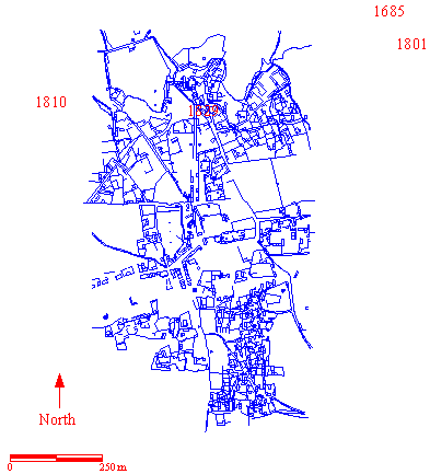
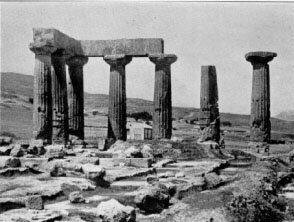
Nearly every traveler who visited Corinth mentions the temple, and the majority of the illustrations that survive are also of the temple. Three issues come up in the different descriptions: the identification of the temple, the reason for the destruction of four columns between 1776 and 1800, and the rediscovery of the columns after the War of Independence. The question of the temple’s identification is the most popular one for comment: 16 of the travelers either suggest a deity or discuss the variety of suggestions of others. Up to 1848, the suggestions vary wildly. Three suggest Octavia (one of which also suggests Juno), three Neptune (one of which also suggests Venus), two Juno (one of which also suggests Octavia) and three discuss the multiplicity of suggestions. After 1848, 5 of the seven travelers suggest Minerva Chalinitis. Interestingly, only one traveler, Keppel, suggested an identification with the Temple of Apollo, which is the current candidate and has been since its excavation at the turn of the century.

Three travelers comment on the destruction of the 4 columns. Clarke (1800) and Fuller (1818) both suggest that the owner destroyed the columns because he wanted to use the material for his building project, and Clarke names the owner as the Governor. Turner (1813) believes that the Turk wanted merely to make room for his addition. It is hard to know which explanation was the truth, and in fact, it might have been both.

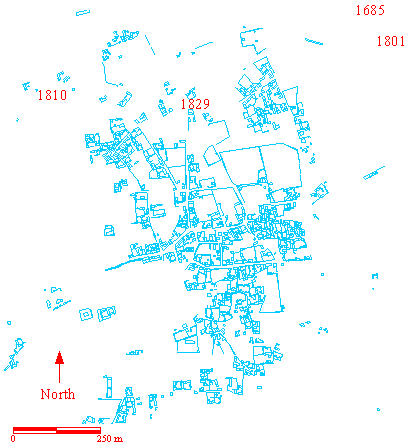
The travellers who visit Corinth as it is being rebuilt after the War of Independence (1821-1829) describe the temple as if it had been buried with debris. In 1829, Keppel writes that five were found when the debris was cleared from that area. However, Trant, who also travelled in 1829, describes all seven. Fitzmaurice, who travelled in 1832, describes only three columns found. Estourmel, also travelling in 1832, notes that seven columns were found by soldiers. While everyone but Trant described the columns as having been “found” that seems possible, but as there is not complete accord between the four of them, and the number of columns found varies in a way that doesn’t make sense, it is hard to know exactly what was to be seen at this time. However, as this is the only abberation in terms of number of columns reported other than Leroy, it seems clear that something was making the counting of the columns difficult.

Dreux 1665-1669

“Mais les Romains brulerent tellement cette belle ville quand ils las prirent qu’il n’y reste plus que quelques colonnes, qui sont les restes d’un ancien palais, et une ancienne porte de la ville…”

But the Romans burned this beautiful city so much when they took it that there are only a few columns left, which are the remains of an old palace, and an old city gate... (158)

Spon 1675-1676

“Nous sumes saluer Panagioti Cavallarie marchand Athenien, qui fait presque toujours la sa residence. Son frere demeure aussi au bazar et nous vimes chez luy une inscription Latine de Faustine femme de l’Empereur Antonin. Nous allames voir une douzaine de colonnes, qui paroissent de loin sur une eminence, un peu plus haute que le Bazar, a la maison du Vayvode. C’est le reste de quelque Temple des Payens. Ces colonnes me parurent le plus antiques qu’aucunes qu j’eusse jamais vues a cause de leur extraordinaire proportion. Car bien qu’elles soient d’Ordre Dorique, elles n’ont point la meme proportion que les autres qui se trouvent a Athenes, et ailleurs…(discusses measurements) Du reste elles sont semblables a celles d’Athenes etant canelees et sans base. Les architraves qui restent encore dessus sont de grandes pierres de 12 pieds de long.”

We came to greet Panagioti Cavallarie Athenian merchant, who almost always makes it his residence. His brother also lives in the bazaar and we saw at his house a Latin inscription of Faustina, wife of the Emperor Antoninus. We went to see a dozen columns, which appeared from a distance on an eminence, a little higher than the Bazaar, at the house of the Vayvode. It is the remains of some Temple of the Pagans. These columns seemed to me the most ancient than any I had ever seen, because of their extraordinary proportion. Because although they are of Doric Order, they do not have the same proportion as the others which are in Athens, and elsewhere... (discussed measurements) Moreover they are similar to those of Athens being fluted and without base . The architraves that still remain on it are large stones 12 feet long. (296-7)

Wheler 1676

“Some distance Westwards of this, (the house in which he found some inscriptions), and upon a Ground somewhat higher than the Bazar, we went to see eleven Pillars standing upright. They were of a Dorick Order, channeled like those about the Temple of Minerva, and Theseus at Athens: the matter of which Pillars we found to be ordinary hard Stone, not Marble: But their Proportion extraordinary; for they are eighteen foot about, which makes six foot Diameter, and not above twenty foot and an half high; the cylinder being twenty, an the Capitals two and an half…There is a Pillar standing within these, which has the same Diameter: but is much taller than the others, although it hath part broken off, and neither Capital nor Architrave, remaining near it: so that of what Order it was, is yet uncertain. The others are placed so with their architraves, that they shew, they made a Portico about the Cella of the Temple: And the single Pillar is placed so towards the Western-end within, as shews it supported the Roof of the Pronaos.” (440)

Pococke 1736-1740

“At the southwest corner of the town are 12 fluted doric pillars about five feet in diameter and very short in proportion…” (describes and compares with Parthenon, 7 pillars are to the west and 5 to the south, one pillar without a cap is near them) (174)

Chandler 1765

“The chief remains are at the southwest corner of the town and above the bazaar or market, 11 columns supporting their architraves, of the doric order, fluted, and wanting in height near half the common proportion to the diamter. Within them, toward the western end, is one taller, though not entire, which it is likely, contributed to sustain the roof.” (240)

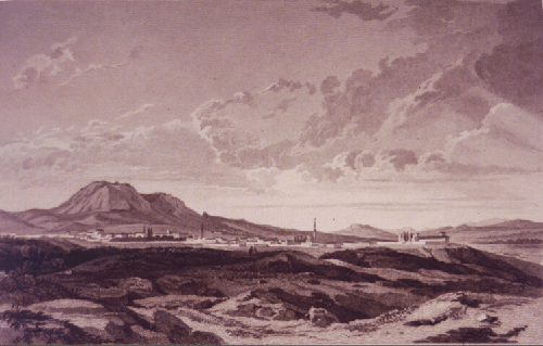
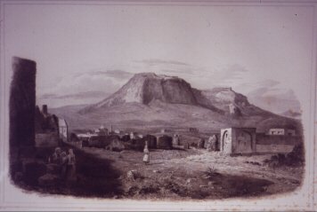
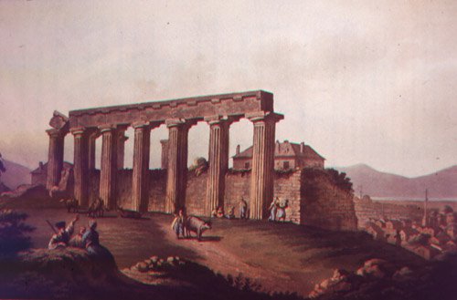
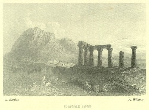
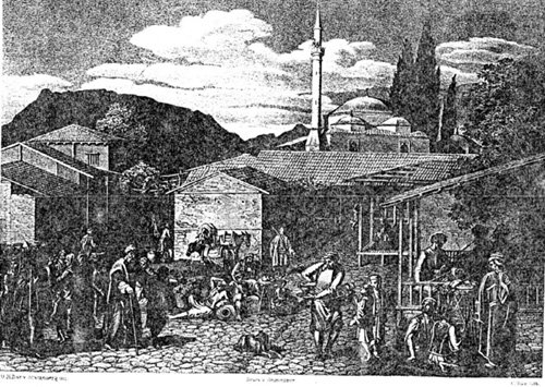
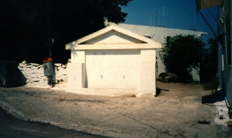
Dodwell 1801-1806 (figure 5)

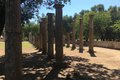
“...But at present seven only are standing, which rest on one step.” (191)

Clarke 1800-1803

“In going from the area of this building towards the magnificent remains of a Temple now standing above the bazar whence perhaps the doric pillar already mentioned may have been removed, we found the ruins of antient buildings; particularly of one partly hewn in the rock opposite to the said temple. The outside of this exhibits the marks of clamps for sustaining slabs of marble once used in covering the walls, a manner of building perhaps, not of earlier date than the time of the Romans…” “In this building were several chambers all hewn in the rock, and one of them has still an oblong window remaining. We then visited the temple.” (remarks that Wheler found 11 but now there are only 7) (550-551)

“We found only seven remaining upright: but the fluted shaft before mentioned may originally have belonged to this building, the stone being alike in both; that is to say, common limestone, not marble, and the dimensions are, perhaps, exactly the same in both instances, if each column should be measured at its base.” (552)

“The destruction that has taken place, of four columns out of the eleven seen by Wheler and Chandler, has been accomplished by the governor, who used them in building a house; first smashing them into fragments with gunpowder.” (552)

He identifies the temple as that of Octavia. “...This temple occupied the same situation with respect to the agora that the present ruin does with regard to the Bazar; and it is well-known that however the prosperity of cities may rise or fall, the position of the public mart for buying and selling usually remains the same.” (555)

Hughes 1813

We “strolled through the town which contains little to remind the traveller of Corinthian splendour, except a few columns of some temple, which antiquarians find very difficult to identify: their antiquity is attested by their massive structure…” (241)

Turner 1813

“Corinth contains within its walls no remains of antiquity, but some small masses of ruined walls, and seven columns, with part of the frieze, of a Temple, of which some columns were pulled down to make room for a miserable Turkish house, to which it joins. These columns are about 60 feet high and 10 in circumference. They are supposed by some travellers (among whom, Dr. Leake) to be the ruins of the temple of Juno.” (292)

Bramsen 1813-1814

“...the antiquities of the place, which include, among many other objects worthy of attention, the remains of the temple of Juno, those of the temple of Octavia and the singular dripping fountain of the nymph Pirene…” (55)

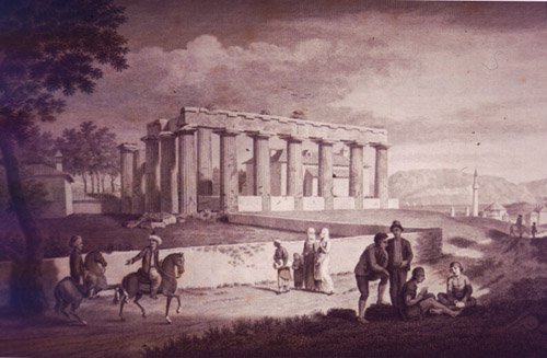
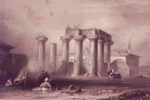
Williams 1816 (figure 6)

Identification of temple unknown: Juno, Venus, Neptune? Chandler says Sisypheum mentioned by Strabo. Proportions are like the Neptune temple at Paestum. (393-394)

Woods 1816-1818

The temple “...figured in Stuart, the first building we saw of Grecian times. In his days eleven columns were still standing. Now there are only six, but is yet a magnificent ruin…” (228)

Fuller 1818-1820

“They [the columns] are of porous stone and were originally encrusted with a red cement, some traces of which still remain. When Chandler visited Corinth, and even down to a much later period, eleven of them were still standing, but the Turkish proprietor took down four the employ the materials in the rebuilding of his house.” (33)

Keppel 1829-1830

“A Cephaloniote has been commissioned by the government to erect some public buildings and the governors’ house is in progress. Near the site of this building, the workmen employed in clearing away the rubbish have discovered five Doric columns, belonging, I believe, to a temple dedicated to Apollo.” (11)

Trant 1829-1830

“In the town are seven columns of a Doric temple supposed to have been dedicated either to Venus or Neptune; they bear the marks of great antiquity and are singular, as the shafts are formed of but one piece.” (313)

Fitzmaurice 1832

“Of the ancient remains of Corinth there is nothing but the front of a Temple with three columns; certainly a poor specimin of its former architecture.” (69)

Estourmel 1832

“...Quelques soldats errent au milieu de ses debris, en cherchant a piller, et dans cette solitude, qui semble maudite, sept colonnes (Chandler eu trouver douze) d’ordre dorique, demeurees debout et qu’on croit avoir apartenu au Temple de Neptune, temoignent seules que, dans un autre temps, il fut des Dieux pour Corinthe…”

...some soldiers wander in the midst of its debris, seeking to pillage, and in this solitude, which seems accursed, seven columns (Chandler found twelve) of the Doric order, which remain standing and which are believed to have belonged to the Temple of Neptune, alone testify that, in another time, there were gods for Corinth... (86)

Burgess 1834

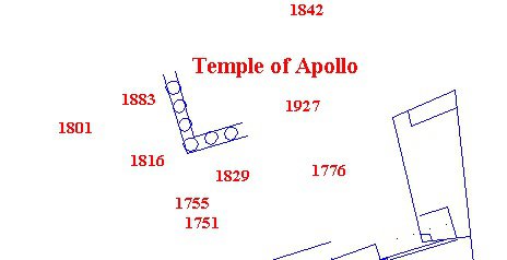
“There exist but seven columns of a Temple or portico…the entablature resting upon five of them, one (marked 6) [he gives a schematic drawing of the locations] wants a capital, there are vestiges of tryglyphs.” (166)

Author chooses to identify temple as the Portico of Octavia and therefore the temple is Augustan in his view. (166)

Quin 1834

“The celebrated ancient columns, each formed of one block of stone, which every traveller has noticed, are in Corinth, with the exception of the Acrocorinthus, the only objects worth attention in the way of 'lionizing.’” (213)

Temple 1834

“Opposite the governor’s house are the remains of a Doric Temple…” (60)

Addison 1835

“Over these [shattered remains of Turkish mosques], in front, were seen the seven majestic Doric columns of the ancient temple and behind the lofty acropolis…” (16)

Stephens 1835

“...Seven columns of the old temple are still standing, fluted and of the Doric order…” (49)

Giffard 1836

“A Temple situated in the upper part of the town has given rise to much discussion as to the date of its erection and the deity to which it was dedicated.” (102)

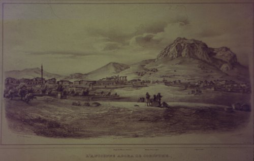
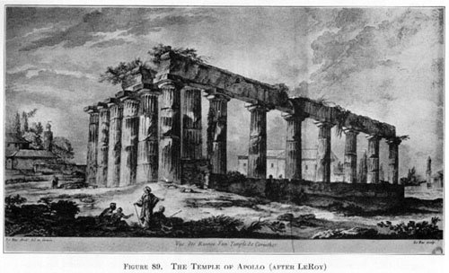
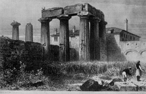
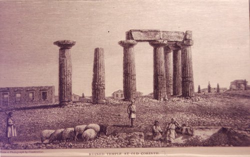
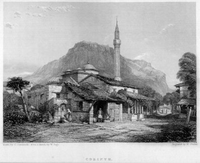
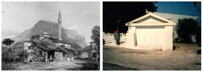
Blouet 1839 (figure 7)

“...Sur le point le plus eleve de ville, se retrouvent les ruines d’un temple: cinq colonnes de la facade posterieure resent encore debout, ainsi que deux de la partie laterale; presque toutes sont surmontees de l’architrave; elles sont en pierre calcaire et etaient couvertes d’un stuc qui les revet encore en plusiers endroits…Stuart, qui a donne une description desrestes de ce temple avait trouve quatorze colonnes debout lors de son voyage.”

...on the highest point of the city, there are the ruins of a temple: five columns of the rear facade are still standing, as well as two of the lateral part; almost all are surmounted by the architrave; they are made of limestone and were covered with a stucco which still coats them in several places…Stuart, who gave a description of the remains of this temple, had found fourteen upright columns during his journey. (36)

Cusani 1840

“Unici avanzi sono alcune colonne isolate nella parte piu alta della citta; (discussion of temple identification) e molti frammenti di cornici, capitelii e fregi adoperati invece di mattoni nelle nuove case, o dispersi fra i campi adjacenti.”

The only remains are some isolated columns in the highest part of the city; (discussion of temple identification) and many fragments of cornices, capitals and friezes used instead of bricks in the new houses, or scattered among the adjacent fields. (184)

Denison 1848

“We then mounted our horses and passed the seven celebrated columns supposed to have belonged to the temple of Minerva Chalamatis.” (141)

Hettner 1852

“They [the columns] show, moreover, evident traces of having been coated with stucco and colored red.” (134) Identifies it as Athena Chalinitis. (134)

Olin 1852

“A single temple of all the splendid structures which adorned ancient Corinth, the most opulent and luxurious town of Greece, now remains, or rather seven columns remain to show where a magnificent temple of Neptune once stood.” (143)

Howe 1853

Identifies it as the temple of Minerva Chalamatis. (35) “Of these [seven columns] three on the side and two adjoining on the front, still support their entablature; the architrave of both others is gone. They are limestone monoliths, near six feet in diameter at the base, heavy and ill-proportioned. This temple is supposed to have been erected in bc. 700, which may well account for its architectural defects. It stands in close proximity to the present village.” (35-36)

Baird 1855

“On our return to Corinth, we spent a short time in the examination of the only objects of interest that remain in thesite of a city which once exceeded Athens for commerce and population—a temple in the very midst of the modern village, and an amphitheater about three quarters of a mile east of it. The former is a hexastyle doric temple, of which only five columns belonging to the front and two on one of the sides are yet standing…” (158)

Burnouf 1856

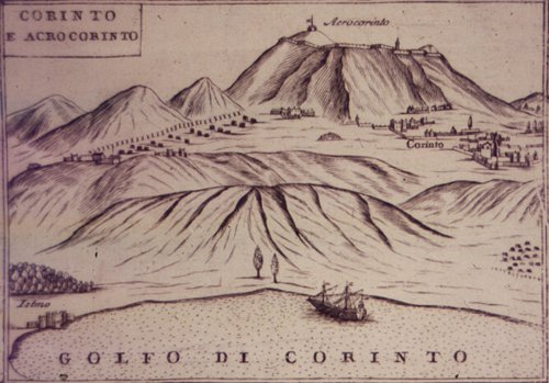
“Le temple est a l’occident de la ville moderne, un peu vers le sud, au pied de l’Acrocorinthe, dans une position assez elevee pour qu’on poisse le voir de loin. Il est etabli sur la roche tertiaire dont l’escarpement forme le premier gradin de la plaine.”

The temple is to the west of the modern city, a little to the south, at the foot of the Acrocorinth, in a position high enough to be seen from afar. It is established on the Tertiary rock whose escarpment forms the first step of the plain. (42)

7 columns, five with architrave, gives measurements. (42)

“...On y voit encore de grands morceaux du stuc jaune dont elles etaient revetues.”

You can still see large pieces of the yellow stucco with which they were covered. (42)

Taylor 1857

“We passed awhile before the seven ancient Doric columns of the temple of Neptune, of the Corinthian Jove or of Minerva Chalcidis or whatever else they may be.” (157)

“One of them [columns] has been violently split by the earthquake and a very slight impulse would throw it against its nearest fellow, probably to precipitate that in turn…” (158)

Wyse 1858

Identification of Athena Chalinits.

Pressense 1864

“De vieille Corinthe il ne reste que cinq colones dorique d’un style tres lourd et un amphitheatre romain. Un tremblement de terre, survenu il y a dix ans a jonche le sol de ruines plus moderne.”

Of old Corinth there are only five Doric columns of a very heavy style and a Roman amphitheater. An earthquake, which occurred ten years ago, littered the ground with more modern ruins. (316)

Jerningham 1870

Identifies temple as Athena Chalinitis. (86)

Belle 1875-1878

“Elles sont criblees de trous carres creuses par les Turcs pour y placer les poutres des masures qu’ils avaient appuyees contre les ruines…Cette colonnade, rongee a la base, briser, jetee hors d’aplomb par les tremblements de terre.”

They are riddled with square holes dug by the Turks to place there the beams of the hovels which they had leaned against the ruins... This colonnade, corroded at the base, broken, thrown out of plumb by the earthquakes.

Mahaffy 1876

“In the middle of the wretched straggling modern village there stand up seven enormous stone pillars of the Doric order…” (364)

Freeman 1877

“The columns stand over the modern village, over a site almost as desolate as that over which they must have stood in the hundred years between Mummius and Caesar. The other fragments, Greek and Roman, hardly come into view. But the lower city is not the true Corinth. It is the mountain citadel round which the great associations of the city gather.” (189)

Miller 1894-1898

“A few columns are all that is left.”

Bazaar and Mosque

modern_bazaarmap01

Figure 1. Plateia of Ancient Corinth, 1831 in dark blue, 1963 in light blue. Digitized by the Corinth Computer Project.

The map (Fig. 1) above shows the location of the images that will be shown and analyzed below. Each image is located on the map with a date in red. This map shows the plan of the village center in 1831 (dark blue) and in 1963 (light blue).

There are three views of the central mosque and the bazaar in my collection, but I do not yet have permission to show the third, which is a view from the south. The two pictures (Figs. 2, 4) however, showing the central mosque, the bazaar and several of the roads, confirm the identification of the old bazaar with the modern plateia, the identity of the Turkish roads in the area with the modern roads, and the shared site of the mosque and the modern church. This is supported by the comparison between the 1963 map and the 1831-33 map as shown in Fig. 1 above.

The images provide other evidence for the appearance of the village in the 19th c. beyond just its layout. The three of them together provide a view of the central mosque and the area around it from three different sides, providing a kind of 360 degree view of that central neighborhood.

modern_bazaar02

Figure 2. Potential view of the bazaar, 1811, Von Stackelberg. Courtesy of the Corinth Excavations, American School of Classical Studies at Athens.

Although Fig. 2 is not labeled, it seems to be a likely candidate for the village bazaar that is described by the travelers. Behind the bazaar is a large mosque with a short minaret and (to its right) a small outbuilding, probably hexagonal or octagonal. To the left of the building with the horses in front is what appears to be a street—one can just make out the people walking down it away from the bazaar. The distinctive outline of Mount Gerania, with the projection at the far right, makes it clear that the view is taken looking east. Using the location of the bazaar and central mosque from the 1831-33 map as a guide, it seems likely that that is indeed what this image is.

modern_bazaar03plateia

Figure 3. Ancient Corinth Plateia, 1995, looking east. Photograph by Leslie Kaplan.

One can compare this image with a modern photo (Fig. 3), taken of the east side of the modern plateia with the church in the background. A side-by-side comparison shows that it is strikingly similar (Fig. 4). In Fig. 1, where the 1831-33 map is superimposed on top of the 1963 map, it is easy to see that the modern church (in light blue with a cross at center, to the left of the word “plateia”) is built on the site of the old mosque (the two small dark blue hexagonal buildings on top of the church and the dark blue rectangular building with the semicircle attached just above and to the left of the church) and that the modern bazaar is on the site of the old. The roads in this area also seem to be on their pre-independence locations; the one to the right of the Von Stackelberg image is the same as the one in the modern photograph. This evidence confirms the similarities of the two town plans and the location of some of the central features of the old village.

modern_bazaar06platcomp

Figure 4. Side-by-side comparison of figures 2 and 3.

modern_bazaar04mosque

Figure 5. Central mosque from the east looking northwest, 1810, Von Stackelberg.

After making the discovery of the location of the central mosque, this picture (Fig. 5) became interesting. Several clues led me to conclude that it is also an image of the central mosque, this time from the east, looking northwest. This is the back side of the Von Stackelberg image (Fig. 2). The location of the minaret in relation to the mosque, and the orientation of the two smaller domes suggest that the mosque faced west, as the central mosque did. The outbuilding to the northeast is also suggestive of the plan of the central mosque. The road going off to the right and back of the picture is then the road featured in the right hand side of the Von Stackelberg image (Fig. 2).

modern_bazaar05fountain

Figure 6. Ancient Corinth, 1995. Photograph by Leslie Kaplan

And finally, the fountain in the central foreground clinched the identification; as seen in this modern photograph (Fig. 6), there is a fountain which is now located on the other side of the same street. A side-by-side comparison shows this similarity (Fig. 7).

Descriptions which use the remains of the temple, the bazaar or the central mosque can now be examined with an eye towards placing them.

modern_bazaar07fontcomp

Figure 7. Side-by-side comparison of figures 5 and 6.

Travelers’ Texts

Spon 1676

“Nous allames voir une douzaine de colonnes, qui paroissent de loin sur une eminence, un peu plus haute que le Bazar, a la maison du Vayvode.” (297)

Wheler 1676

“The Houses are more spruce here, than ordinary; and the biggest quarter is, where the Bazar, or Market place is, consisting of about fourscore, or an hundred Houses. There are two Mosques here, and one small church, called Panagia; at which the Arch-Bishop liveth, who was then absent: and few Marks either of his, or St.Paul’s Preaching, Pains or Care of ; this famous Church of Corinth are now to be observed there.” (439-440)

“There is also another Ruin on the North-side of the Bazar, of Brick-work; which looks like part of some Temple or a Roman Bath.” (440)

Clarke 1801-1803

“In going from the area of this building towards the magnificent remains of a Temple now standing above the bazar whence perhaps the doric pillar already mentioned may have been removed, we found the ruins of antient buildings; particularly of one partly hewn in the rock opposite to the said temple.”

“...This temple occupied the same situation with respect to the agora that the present ruin does with regard to the Bazar; and it is well-known that however the prosperity of cities may rise or fall, the position of the public mart for buying and selling usually remains the same.” (555)

Temple 1834

“The town was entirely destroyed during the last revolutionary war, but a few houses are rising out of the ashes; the bazaar is tolerably supplied…” (60)

Addison 1835

“The whole of the houses, with the exception of those just built, in the centre of the village, being heaps of ruins, destroyed by the Turks, or deserted by the inhabitants who have been thinned by the sword and the plague. Bare mud walls, roofless tenements and the shattered remnants of Turkish mosques present themselves on either side…We traversed a rugged path over stinging-nettles and stones, past a fragment of a marble column to the principle street, consisting of a few houses of wood and shops.” (16)

Giffard 1836

“Climbing over masses of masonry and by ruined walls, we at length arrived in the main streets of Corinth. Here there was some little appearance of life and trade, of which the suburbs gave no promise; houses were building and shops were opened, in some of which we recognized the handiworks of Birmingham.” (100)

Bibliography

Sources used in Modern Corinth research

Primary Sources: Travelers’ Texts

Addison, Charles G.. Damascus and Palmyra: A Journey to the East with a Sketch… Vol.1. London: Richard Bentley, 1838.

Baird, Henry M., Modern Greece: A Narrative of a Residence and Travels… New York: Harper and Brothers, 1856.

Belle, Henri. Trois Annees en Grece. Paris: Librarie Hachette, 1881.

Blouet, Abel. Expedition Scientifique de Moree Ordonee par le gouvernement. Vol. 3. Paris: Librarie de Firmin, Didot Freres, 1838.

Bramsen, John. Travels in Egypt, Syria, Cyprus, the Morea, Greece and Italy. Vol. 2. London: Henry Colbourne and Co., 1820.

Breton, Ernest. Quatre Jours dans Le Peloponese. Paris: L. Guerin et Cie, Theodore Morgund, Librarie Depositaire, 1860.

Burgess, Richard. Greece and the Levant, or Diary of a Summers excursion, 1834. Vol. 1. London: Longman, Rees, Orme, Braun, Green and Longman, 1835.

Burnouf, Emile. D’Athens a Corinthe: Extrait des nouvelles annales de voyage. Paris: Arthus Bertrand, 1856.

Chandler, Richard. Travels in Greece ..at the expense of the soc. of Dilettanti. Oxford: Clarendon Press, 1776.

Chenavard, Ant. M. Voyage en Grece et dans le Levant fait en 1843-1844. Lyon: Leon Boitel, 1846.

Clark, W. G. Peloponnesus: Notes of Study and Travel. London: John Parker and Son, 1858.

Clarke, Edward Daniel. Travels in Various Countries of Europe, Asia and Africa. Vol. 6. London: T.Cadell and W.Davies, 1810-1823.

Cochrane, George. Wanderings in Greece. Vol. 2. London: Henry Colburn, 1837.

Cusani, Francesco. La Dalmazia, le Isole Ionie e la Grecia (visitate nel 1840). Vol.1. Milano: Tipographia e Libreria Pirott a E.C., 1846.

Denison, Lord Albert. Wanderings in Search of Health. London: for Private Circulation, 1849.

Dodwell, Edward. A Classical and Topographical Tour through Greece:1801, 05, 06. Vol. 2. London: Rodwell and Martin, 1819.

Dreux, Robert de. Voyage en Turquie et en Grece. Paris: Societe d’edition, Les Belles Lettres, 1925.

Estourmel, Joseph. Journal d’un Voyage en Orient. Vol. 1. Paris: de l’Imprimerie de Crapelet, 1844.

Fitzmaurice, W.E.. A Cruise to Egypt, Palestine and Greece during 5 months leave. London: John Hill, 1834.

Freeman, Edward A.. Studies of Travel: Greece and Italy. New York, London: G. Putnam’s Sons, 1893.

Fuller, John. Narrative of a Tour through some parts of the Turkish Empire. London: John Murray, 1830.

Giffard, Edward. A Short Visit to the Ionian Islands, Athens and the Morea. London: John Murray, 1837.

Grellet, Stephen. Memoirs of the Life and Gospel Labours of Stephen Grellet. Vol. 2. London: A.W. Bennett 1862.

Hettner, Hermann. Athens and the Peloponnese with sketches of N. Greece. Edinburgh: Thos. Constable and Co., 1853.

Howe, Fisher. Turkey, Greece and Palestine in 1853. Glasgow: William Collins, 1854.

Hughes, Thomas Smart. Travels in Sicily, Greece and Albania. Vol. 1. London: J. Mawman, 1820.

Jerningham, Hubert E. H.. To and From Constantinople. London: Hurst and Blackett, 1873.

Keppel, George. Narrative of a Journey across the Balkan…in 1829-1831. London: Henry Colburn and Richard Bentley, 1831.

Leake, William Martin. Travels in the Morea. Vol. 3. London, 1830.

Mahaffy, J.B.. Rambles and Studies in Greece. London: MacMillan and Company, 1876.

Miller, William. Travel and Politics in the Near East. London: T. Fisher Unwin, 1898.

Mure, William. Journal of a Tour in Greece and the Ionian Islands. Vol. 2. London: William Blackwood and Sons, 1842.

Olin, Stephen. Greece and the Golden Horn. New York: J.C. Derbey, 1854.

Perdicaris, G.A.. The Greece of the Greeks. Vol. 2. New York: Paine and Burgess, 1845.

Pococke, Richard. A Description of the East and some Other Countries. London: W. Boyer, 1743-1750.

Pressense, Edmond de. Le Pays de l’Evangile: Notes d’un Voyage en Orient. Paris: Librarie de Ch. Meyrueis, 1864.

Quin, Michael. A Steam Voyage down the Danube with sketches of…etc. Vol. 2. London: Richard Bentley, 1836.

Randolph, Bernard. The Present State of the Morea called anciently Peloponnesus. London: Will. Notts, 1686-1689.

Smith, Agnes. Glimpses of Greek Life and Scenery. London: Hurst and Blackett, 1884.

Spon, Jacob. Voyage d’Italie, de Dalmatie de Grece et du Levant fait 1675. Lyon: Antoine Cellier, 1678.

Stephens, J.L.. Incidents of Travel in Greece, Turkey, Russia and Poland. Vol. 1. New York: Harper and Bros., 1838.

Taylor, Bayard. Travels in Greece and Russia, with an excursion to Crete. New York: G.P. Putnam, 1859.

Temple. Sir Grenville, Travels in Greece and Turkey and the Mediterranean. Vol. 1. London: Saunders and Otley, 1843.

Trant. T. Abercromby, Narrative of a Journey through Greece in 1830… London: Henry Colburn and Richard Bentley, 1830.

Turner. William. Tour in the Levant. Vol. 1. London: John Murray, 1820.

Wheler, George. A Journey to Greece. London: William Cadman, Robert Kettlewell, Awnsham Chruch, 1682.

Williams, Hugh W. Travels in Italy, Greece and the Ionian Islands. Vol. 2. London: 1820.

Woods, James. Letters of an Architect, from France, Italy and Greece. Vol. 2. London: John and Arthur Arch, 1828.

Wyse, Sir Thomas. An Excursion in the Peloponnese in the year 1858. Vol. 2. London: 1865.

Yemeniz, Eugene. Voyage dans le Royaume de Grece. Paris: E. Dentu, 1854.

Primary Sources: Illustrations

Bartlett, W. Corinth in 1842. (postcard, reprint of print)

Blouet, Abel. Expedition Scientifique de Moree Ordonee par le gouvernement. Vol. 3, 1838.

Coronelli, in Corinth Vol 1 Part 1. Cambridge: Harvard University Press, 1932, p. 134.

Dodwell, Edward. A Classical and Topographical Tour through Greece:1801, 05, 06. Vol. 2, 1819.

Le Roy, Les Ruines des plus beaux monuments de la Grece. Vol 2.

Mayer, Luigi. Views in the Ottoman Empire Chiefly in Caramania… 1803.

Smith, Agnes. Glimpses of Greek Life and Scenery. 1884.

Stuart, James and Nicholas Revett. The Antiquities of Athens. Vol. 3, 1794.

Von Stackelberg Williams, H.W. Select Views in Greece with Classical Illustrations. London: 1829.

Primary Sources: Maps

Greek Army Map Service. Village Plan, 1963. Computer version courtesy of Corinth Computer Project, 1996.

G.E. Schaubert (?). Plan Von Korinthe. 1831-33? Computer version courtesy of Corinth Computer Project. Copy from Corinth Archives, Ancient Corinth, Greece.

Secondary Sources

Blue Guide to Greece, Robin Barber, ed. London, 1993.

Cantwell, Robert. Ethnomimesis: Folklife and the Representation of Culture. Chapel Hill: University of North Carolina Press, 1993.

Dorst, John D. The Written Suburb: An American Site. An Ethnographic Dilemma. Philadelphia: University of Pennsylvania Press, 1989.

Fowler, Harold N. “Introduction” Corinth Volume I: Introduction, Topography, Architecture. Cambridge: Harvard University Press, 1932. pp. 3-17.

Glassie, Henry. Passing the Time in Ballymenone. Bloomington: Indian University Press, 1995.

Herzfeld, Michael. A Place in History: Social and Monumental Time in a Cretan Town. Princeton: Princeton University Press, 1991.

Hufford, David. Beings without Bodies. (Draft, 1996).

Kasas, Savas E. Corinth and its Environs in Antiquity. Athens, 1974.

Langridge-Noti, Elizabeth. A Corinthian Scrapbook: 100 Years of American Excavations in Ancient Corinth. Athens: Lycabettus Press, 1996.

Robinson, Henry. “Urban Designs for Corinth, 1829-1833.” Philia Epe Eis Georgios E. Mylonan. Vol 3. Athenai: Archaiologike Hetaireias, 1986.

Stillwell, Richard. “The Temple of Apollo” Corinth Volume I: Introduction, Topography, Architecture. Cambridge: Harvard University Press, 1932. pp. 115-134.

Tsakopoulos, Panayiotis. “Oi Marturies yia tis Poleis tis Peloponneisou.” (“The witnesses for the Cities of the Peloponnese”) Travellers and Officials in the Peloponnese: Descriptions—Reports—Statistics in Honor of Steven Runciman. Monemvasia: Monemvasiotikos Omilos, 1994.

Van der Vin, J.P.A. Travellers to Greece and Constantinople: Ancient Monuments and Old Traditions in Medieval Travellers’ Tales. Leiden: Nederlands Historisch-Archaeologisch Instituut Ti Istanbul, 1980.

Walsh, Kevin. The Representation of the Past: Museums and Heritage in the Post-modern World. New York: Routledge, 1992.

Weber, Shirley. Voyages and Travels in Greece and the Near East and Adjacent Regions, Made Previous to the Year 1801. Princeton: American School for Classical Study, 1953.

————. Voyages and Travels in the Near East in the XIX Century. Princeton: American School for Classical Study, 1952.