Overview of Greek and Roman History

David Gilman Romano, Ph. D.

Corinth was one of the most famous cities of the ancient world. Located adjacent to the Isthmus that joins central Greece to the Peloponnesos, Corinth controlled the land routes across the Isthmus as well as those between the adjacent bodies of water, the Corinthian Gulf to the west and the Saronic Gulf to the east. Corinth established harbors on both: Lechaion on the Corinthian Gulf and Kenchreai on the Saronic Gulf. The city included as its acropolis Acrocorinth, a 573 masl outcropping of rock that rises up only 8 km to the south of the Corinthian Gulf and as such was a strategic military location commanding both land and sea routes. The land immediately to the south of the Corinthian Gulf was a rich agricultural plain that was famous in antiquity. The early political history of Corinth from the 8th c. B.C.E. includes the aristocratic Bacchiadae who were overthrown ca. 650 B.C.E. and succeeded thereafter by a family succession of tyrants, Cypselus and his son Periander.

Greek plan of Corinth ca. 500 B.C.E.

Figure 1. Plan of Greek Corinth, ca. 500 B.C.E. Corinth Computer Project after Williams.

The earliest city of Corinth was a loose collection of communities that were at some distance from one another. The Archaic and Classical city of Corinth grew up to the north of Acrocorinth, some 5 km south of the Gulf of Corinth on a limestone plateau approximately 80 masl. By the 5th c. B.C.E (Fig. 1) the city was surrounded by a fortification wall and by the 4th c. B.C.E also included long walls to the Gulf of Corinth to its harbor at Lechaion. By the 6th c. B.C.E. the Upper Lechaion Road Valley and nearby areas were filled with cults, hero shrines, springs, buildings and monuments as well as a race track, and a series of roadways approached this valley from various directions. The successive temples of Apollo dominated the city of Corinth from Temple Hill and the fountain houses of Glauke and Peirene were found not far away.

In the 8th c. B.C.E. Corinth had founded important colonial cities to the west: Kerkyra, Apollonia, and Syracuse, to name but a few. Corinth was a leader among Greek cities as it had an early example (7th c. B.C.E) of a Greek temple, the Temple of Apollo, as well as having the first example in the Greek world of terracotta roof tiles for its roof. Corinth was also well-known for its pottery that was traded all over the Mediterranean. Its Proto-Corinthian style, first developed by 725 B.C.E, was sent out to many of the earliest colonial Greek sites. Corinth invented the black-figured technique of vase painting 625-600 B.C.E that was copied all over the Greek world.

During the Archaic and Classical period Corinth often allied itself with Sparta and against Athens: during the Peloponnesian War Corinth fought on the side of Sparta. During the 4th and 3rd cs. B.C.E. a Macedonian garrison occupied Acrocorinth under the control of Ptolemy I, Demetrius Poliorcetes, and Antigonos, until being captured by Aratus in 243 B.C.E., when Corinth joined the Achaean Confederacy. In the 2nd c. B.C.E. Corinth was a leader among the Greek cities in their opposition to the coming of Rome in Greece. As a result, the city of Corinth was singled out among all the Greek cities and sacked by the Roman consul Lucius Mummius in 146 B.C.E. who, according to tradition, killed all the men and sent all the women and slaves into slavery. The city was abandoned and it was deprived of a political identity until Julius Caesar founded a new Roman colony on the site of the former Greek city, Colonia Laus Iulia Corinthiensis. The Roman colony imposed a new urban plan for the city as well as a new rural organization to the land of the Corinthia. Later in the 1st c. C.E. a second Roman colony was instituted at Corinth under the Emperor Vespasian, Colonia Iulia Flavia Augusta Corinthiensis. Corinth has been continuously occupied through the Late Roman, Byzantine, Frankish, Venetian, Turkish periods and into the modern day where today it is a small village. Modern Corinth was moved 8 km to the Gulf of Corinth in 1858. The successive ancient cities of Corinth have been under excavation and study by the Corinth Excavations of the American School of Classical Studies since 1896.

146–44 B.C.E. Roman Interim Period

David Gilman Romano, Ph. D.

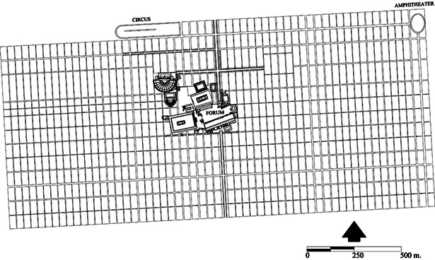
The ultimate price of Corinth’s leadership of the Achaean League in 146 B.C.E. in opposition to the Roman takeover of Greece was its destruction at the hands of the consul Lucius Mummius. According to Pausanias (7.16.8), the male citizens were killed and the women, children, and freed slaves were sold into slavery. The archaeological record seems to indicate that there was a partial and selective physical destruction of the buildings and structures of the city.

Evidence for a Roman Land Survey of Corinth

After the sack of Corinth, the Roman Senate sent ten commissioners to assist Mummius in the settlement of Greece and it is possible that a land survey of the Corinthia occurred at that time. Certainly detailed maps would have been made for the use of the commissioners and for planning the future use of the land; it is further understood that a major administrative reorganization took place. Pausanias implies that a special province, Achaea, was created, although it is more likely that the affairs of Greece were supervised by the governor of Macedonia. The Greek city was stripped of its civic and political identity and the combined literary and archaeological evidence suggests that it lost all semblance of an urban center from that time until 44 B.C.E. when the Caesarian colony was founded on the same site. Cicero mentions that people were living among the ruins during this period and that the confiscated land of Corinth was still vectigalis (taxable) as ager publicus (public land) in 63 B.C.E. Both Livy and Cicero suggest that Sikyon had taken over the care of part of the land of Corinth. Strabo says that the Sikyonians held most of the Corinthian land (chora).

We know from fragmentary elements of a Roman land law — the lex agraria, which is dated to 111 B.C.E. and was passed by the Assembly of Tribes of Rome — that parts of the ager publicus of Corinth, land acquired by the Romans in 146 B.C.E., were measured out for sale. This text is important because it may establish the date when at least a part of the land of the former Greek city of Corinth was formally divided up into Roman plots. It is not actually stipulated in the remaining fragments of the bronze inscription that a limitatio (boundary marking) was carried out at Corinth, and, therefore, scholars have considered the possibility that the Corinthian land was not centuriated at this time or, for that matter, at any time.

Some archaeological evidence exists to suggest that there was indeed a limitatio carried out during the interim period, probably related to the work referred to in the lex agraria. Archaeological evidence for this land division comes from a study of the Roman roads that may be associated with the period between 146 and 44 B.C.E., in the plain to the north of the former city. The evidence suggests that the framework for the organized grid of land to the north of the new city of 44 B.C.E. already existed after 111 B.C.E.

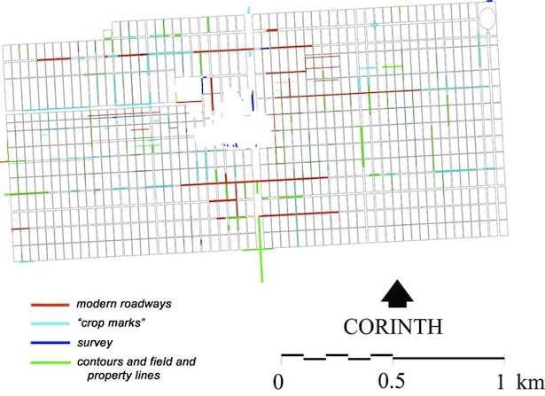
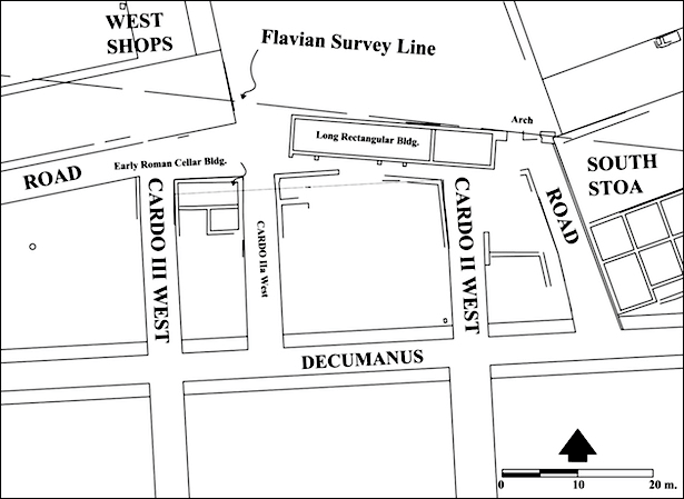
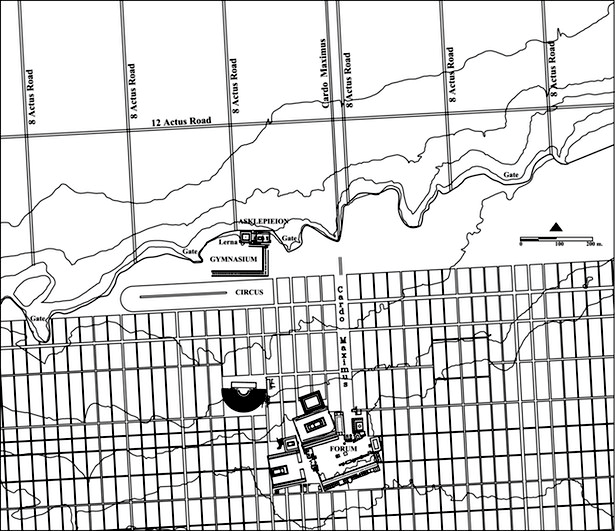
The attested archaeological evidence is found in the area of the Asklepieion, where the remains of a road for wheeled vehicles have been traced along the east-west ramp of the temenos. The wheel ruts of this roadway turn and point toward the northwest corner of the Lerna colonnade, where it is clear that the road passed down into the plain (Fig. 2). It appears that the northern Greek city wall was broken through in this place, in order to give the road a clear route for descent. It must be admitted that the route of the road has not been traced outside the city wall, although it clearly went there. Archaeological evidence indicated that the period of use of this roadway is between 146 and 44 B.C.E. The obvious question to ask is why the Romans wanted to have a roadway in this location at this time, since there were presumably several Greek roadways passing through nearby existing Greek gates in the circuit wall. The most plausible explanation is that the Romans, in following the lex agraria of 111 B.C.E., had divided the land to the north of the city in a formal limitatio. As a result of this, there would have been several new, important roadways going north-south that connected the former Greek city with the northern plain. Because the newly created Roman roads did not necessarily respect the location of the existing Greek gates, the walls would have been dismantled in places where the roads approached the city.

Greek Corinth, 146–44 B.C., with northern Greek circuit wall and interim period Roman land division to the north of the city. Portions of the two modern village roads are indicated.

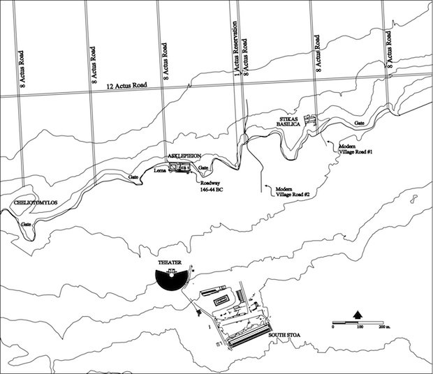
Figure 2. Greek Corinth, 146-44 B.C.E., with northern Greek circuit wall and interim period Roman land division to the north of the city. Portions of the two modern village roads are indicated. Contour lines are at intervals of 10 m. Corinth Computer Project.

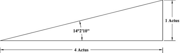
Evidence for land division into units of 16 × 24 actus (a linear measure of 120 Roman feet) at the orientation of 3° west of north is attested north of the city and is described below as a part of the discussion of the colony of 44 B.C.E. Evidence also exists for a sub-division of the 16 × 24 units into 8 × 12 units between the long walls, which would allow for a roadway where the Greek circuit wall has been broken through at Lerna. Since this road dates to the interim period, 146–44 B.C.E., can the other roads in the same system be dated similarly?

Furthermore, it appears that there was planned into this system of centuriation to the north of the former Greek city a reservation of one actus between the central 16-actus strips (Fig. 2), which suggests planning for an iter populo non debetur (“a public right of way does not exist over private land,” i.e. a public thoroughfare) 120 Roman feet wide. If this work was done in the year 111 B.C.E., then we may assume that the surveyors were already planning for the settlement of the former Greek city as a Roman colony, for it is possible that the reservation of one actus was included for a thoroughfare or for public buildings between city and port.

There is supplementary evidence for the organization of 146–44 B.C.E. in the existence of two modern roads that enter the village from the north and which are spaced at distances that suggest the organization cited above. Seventeen actus (2 × 8 actus units plus 1-actus reservation) to the east of the road at the Asklepieion is a farm road that leaves the plain and ascends the scarp towards the city plateau (Fig. 2, village road #1). This modern village roadway passes immediately to the east of the Early Christian basilica of Haghios Kodratos, dated to the 5th c. C.E. The basilica was built on the site of a Roman cemetery, and although its original date is not known, the road may be another feature of the land division of the 2nd c. B.C.E. Today a third roadway, probably another roadway of the same system, enters the city approximately midway between the two roads described above and at the 8-actus division of the Roman planning, (Fig. 2, village road #2). The association of village roads 1 and 2 with the 111 B.C.E. lex agraria is hypothetical without firm archaeological evidence. However, the location of the three roads with respect to each other suggests that the three may have been a product of the same project.

Although it is not clear at this time exactly how much of the Corinthia was included in the limitatio of 111 B.C.E., there probably was at least a regular and organized Roman division of land in the area immediately north of the former Greek city, and between the remains of the Greek long walls, where 16 × 24 actus units were subdivided into 8 × 12 actus units (Fig. 2, Fig. 3). In the present study this centuriation is documented as far west as the Longopotamos River, which may have been the border between Corinthian and Sikyonian land in the 2nd c. B.C.E. It is difficult to say how much of the rest of the Corinthia was centuriated at this time.

Greek Corinth, 146-44 B.C., illustrating the locations of the two east-west interim period roadways.

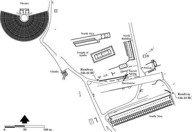
Figure 3. Greek Corinth, 146-44 B.C.E., illustrating the locations of the two east-west interim period roadways. Corinth Computer Project after Williams.

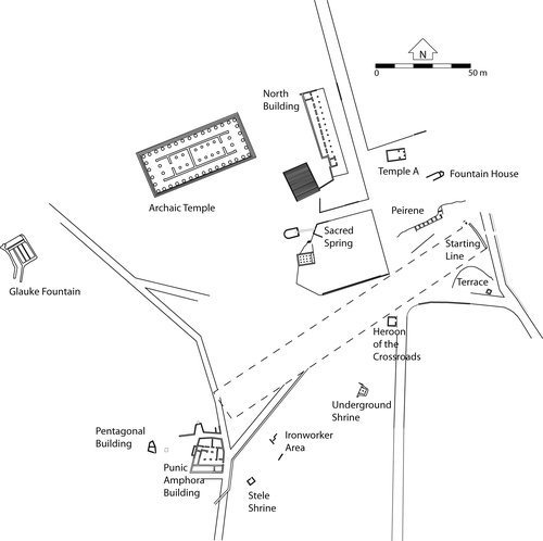
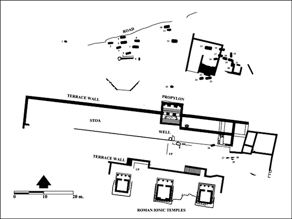
At least two other roadways dating to 146–44 B.C.E. exist near the center of the former Greek city. Wheel ruts going roughly east-west and crossing a low foundation at the northeast end of the South Stoa indicate that heavy-wheeled traffic used this route as a roadway (Fig. 3). That the roadway was abandoned shortly after the founding of the colony must, at least in part, be due to the fact that the construction of the Southeast Building closed off this corner of the forum. The roadway from the eastern end of the South Stoa has been traced across portions of the later Forum toward the west. Evidence for the second roadway datable to this period is found in the area of the temenos of the Sacred Spring. Deep wheel ruts (east-west) have been worn into the Greek triglyph terrace wall, ca. 15 m south of the Apsidal Building, and into bases of statues along the side of the abandoned sanctuary to the west of the triglyph wall (Fig. 3).

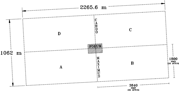
The combined evidence suggests that there was activity on the land and in the former city of the Corinthians before the time of the formal colonization in 44 B.C.E. It is assumed that the orientation and division of a limitatio of 111 B.C.E. was retained in the plain to the north of the city when the colony of 44 B.C.E. was founded.

44 B.C.E. Planning the Caesarian Colony

David Gilman Romano, Ph. D.

Founded by Julius Caesar in 44 B.C.E., the Roman colony of Corinth, Colonia Laus Iulia Corinthiensis, was laid out virtually on top of the former Greek city that had been destroyed by the Roman consul Lucius Mummius in 146 B.C.E. The site had remained largely uninhabited for 102 years. According to literary sources, the Greek male population had been killed and the women and children had been sold into slavery.1

The location of Corinth had been important during the Greek period, situated near the Isthmus, the land bridge between the Peloponnesos and mainland Greece, as well as having ports on the Saronic Gulf and the Corinthian Gulf.

In the new foundation of 44 B.C.E. the Romans utilized many of the existing Greek buildings in the design of their own city, although the organization and city plan of the Roman colony was different than its Greek predecessor. Additionally, evidence exists for what are likely to be several phases of Roman agricultural land division (centuriation) of the territorium (territory) of the city. There is also epigraphical, numismatic and now archaeological evidence for a refoundation of Roman Corinth as Colonia Iulia Flavia Augusta Corinthiensis under Vespasian in the early 70’s C.E.

Cityscape Planning

This map illustrates the comparative sizes and locations of the Greek and Roman cities of Corinth. The Greek city includes the area within the 5th c. B.C.E. wall circuit. Fortification walls also enclose Acrocorinth and the area within the long walls to the Corinthian Gulf. The location of the west long wall is hypothetical and is reconstructed by the Corinth Computer Project, based on a study of the field and property lines of the area to the north of the city. All of the walls are indicated in grey on the map.

A simple outline map with color coding to indicate comparative sizes and locations of the Greek and Roman cities of Corinth.

Figure 4. A simple outline map with color coding to indicate comparative sizes and locations of the Greek and Roman cities of Corinth. Corinth Computer Project.

The urban aspect of the Roman colony of 44 B.C.E. was planned to occupy a large portion of the area of the former Greek city (Fig. 4). The location of the Roman city is indicated in blue and the area of the forum is indicated in red. The cardo maximus, also known as the Lechaion Road, is shown as a white line.

Greek City

  • Perimeter of circuit wall: 10.29 km
  • Area within circuit walls (including Acrocorinth): 5.55 km2
  • Area within long walls: 6.77 km2

Roman City

  • Urban area: 2.41 km2

Roman Surveying

The groma was the principal surveying instrument of the Roman agrimensores, the land surveyors (Fig. 5). The instrument itself was simple in design, crossed arms resting on a bracket and attached to a vertical staff. The four arms each had a cord with a hanging plumb bob. It was designed to survey straight lines and right angles. This drawing is of a replica of a groma, which is now in the Science Museum, London. The original metal parts were found in the workshop of the surveyor Verus at Pompeii, and are now in the Museo Nazionale, Naples.

Ancient Roman groma schematic.

Figure 5. Schematic of a groma.

We are fortunate to have the tombstone of a Roman surveyor — Lucius Aebutius Faustus, of the 1st c. B.C.E. — with a sculpted relief which depicts certain attributes of his profession (Fig. 6). The component parts of the sculptural relief are the following: In the pediment are a shield and spears. Beneath the inscription is a dismantled groma. Above this are the symbols of a sevir (member of a municipal directory of 6 men), two fasces and between them a low seat.

The tombstone is in the Museo Civico at Ivrea in Northern Italy.

Roman Surveyor Tombstone

Figure 6. Tombstone of the Roman surveyor Lucius Aebutius Faustus.

The stone relief has a Latin inscription which is translated as follows:

"Lucius Aebutius Faustus, freedman of Lucius Aebutius, of the tribe of Claudia, surveyor, sevir, erected this monument while still alive for himself and his wife Aria Aucta freedwoman of Quintus Arrius, and their children, and the freedwoman Zepyra."

The plumb-bobs of a Groma

Plumb bobs of a groma

Figure 7. Plumb-bobs of a groma.

These plumb-bobs are examples of what Roman carpenters, bricklayers, and surveyors used to trace vertical lines and to determine horizontal planes. Plumb bobs are usually conical and are either made of bronze or iron.

Descriptions from Top to Bottom:

  • Left, H. 4 cm, Diam. 4.7 cm. Bronze; Right, H. 4.5 cm, Diam. 6 cm. Bronze
  • Left, H. 2.7 cm, Diam. 2.5 cm. Bronze; Right, H. 3 cm, Diam. 2.2 cm. Bronze
  • Left, H. 5.3 cm, Diam. 4.6 cm. Bronze; Right, H. 5 cm, Diam. 3.6 cm. Bronze

Photo Credits:

  • Musei Capitolini, Rome, Italy
  • Museo Nazionale, Rome, Italy
  • Museo Nazionale, Rome, Italy

The Point of a Groma

Point of a groma that would have stabilized the apparatus in the ground.

Figure 8. The point of a groma.

The point (above), usually made of bronze, was placed on the end of a staff to secure the groma in its position before surveying. It is possible that this example was used either on a groma or on a measuring staff.

Descriptions:

  • Diam. 1.5 cm. Bronze

Photo Credits:

  • Museo Nazionale, Naples, Italy

1 For a general discussion of the history of Corinth during this time period, see Wiseman, James. “Corinth and Rome I: 228 B.C.–A.D. 267.” Aufstieg und Niedergang der Romischen Welt II, 7.1 (1979): 438-548.

44 B.C.E. An Urban Colony

David Gilman Romano, Ph. D.

The foundation of Colonia Laus Iulia Corinthiensis by Julius Caesar in 44 B.C.E. is attested in various ancient authors as well as by numismatic and epigraphical material. Archaeological evidence for the organization and structure of the urban elements of the colony has been recovered from many sources, including the Roman roads of the city. Excavated roadways having the orientation and the location of the colonial period grid now number 22: 13 running north-south and 9 east-west (Fig. 9). Some have been known for many years, and several are paved. The paving may date to the years following the earthquake that damaged Corinth in the 70's C.E.

Evidence for roadways in the Caesarian colony of 44 B.C.E

Figure 9. Evidence for roadways in the Caesarian colony of 44 B.C.E from all available sources. Corinth Computer Project.

Where the curbstones of the roadways exist, they have been surveyed by means of an electronic total station and accurately plotted within the framework of the Greek Army Geodetic Survey. To this information has been added the evidence of the 1:2000 topographical maps, which include modern village roads, ledges, paths, property lines, and contours, and of rectified low-level air photographs. This has been further supplemented by the information from Corinth Excavations notebook drawings and from topographical and architectural reports.

The evidence for the organization of roads within the urban plan of Colonia Laus Iulia Corinthiensis is synthesized in Figure 10. This illustrates all of the combined evidence for what I call the “drawing board” plan of the colony, the plan that the colonists may have brought with them from Rome. I use the term “drawing board” for a number of reasons. It appears from the archaeological evidence that although the urban colony was originally designed to be of a certain size and shape, and to have contained a specific number of cardines and decumani, the original, or “drawing board,” plan may not have been entirely carried out, as is discussed below.

Drawing Board plan of the urban colony of 44 B.C.E.

Figure 10. “Drawing Board” plan of the urban colony of 44 B.C.E. Corinth Computer Project.

The Planning and Orientation of the Urban Colony of Julius Caesar

The principal north-south orientation of the colony of 44 B.C.E. is approximately 3° west of north. The evidence suggests that the “drawing board” plan called for an overall urban design which was based on 4 equal quadrants (centuriae), each 32 × 15 actus, or 240 iugera (Fig. 11). The per strigas (by bands) plan placed a total of 29 cardines and 29 insulae, each 1 actus wide, in each of the four centuriae, which would put 200 iugera of land in each, excluding the roads and the Forum. The evidence suggests that the predominant insula size of this original plan was 1 × 2 actus.

Schematic drawing of the four quadrants of the urban colony, each of which is 32 × 15 actus, with centrally located forum and cardo maximus.

Figure 11. Schematic drawing of the four quadrants of the urban colony, each of which is 32 × 15 actus, with centrally located forum and cardo maximus. Corinth Computer Project.

The Lechaion Road was the principal cardo (cardo maximus) of the urban colony; there is abundant evidence from the excavations in the city as well as from low-level photographs of the region near the Lechaion harbor some 3000 m to the north. In the 1st c. C.E., the Lechaion Road, including its sidewalks, was 50 feet wide. The average width of each of the remaining cardines of the city grid was ca. 12 feet. In the urban center, the Lechaion Road (cardo I east) was technically a part of the eastern two centuriae of the city. There probably were 6 decumani in both the south and north half of the colony, for a total of 12, each having an average width of 20 feet.

The original urban plan extended from the amphitheater on the northeast to the area of modern Anaploga on the southwest. The overall dimensions of the city were 2265.6 m east-west (7680 Roman feet) by 1062 m north-south (3600 Roman feet). The total area of the city would have been 2.4 km2, or 240 ha, with its entire area within the walls of the Greek city. Only at the northwest in the area of Cheliotomylos did a small section of the rectilinear “drawing board” plan fall outside the Greek circuit wall; this would not have been developed as part of the actual city.

The specific evidence that contributes to the definition of the limites of the northeast corner of the city includes the orientation and location of the amphitheater, apparently an element of the original plan. This structure has as its southern entrance one of the cardines of the original colonial plan, cardo XXVIII east. Several additional cardines in the vicinity of the amphitheater are clear from the low-level air photographs. At the southwest, in the area of Anaploga, some of the modern village streets still reflect the actus measurements. Other cardines of the “drawing board” plan are evident in the landscape from the low level air photographs (Fig. 9). Topographical irregularities as well as specific necessities of design will have caused some modifications in the original plan.

During ten summer seasons of fieldwork it was possible to survey diagnostic elements of virtually every surviving above-ground structure of the Roman city; this work has greatly added to our understanding of the planning and organization of the colony. It has thus been possible to produce a map which includes not only the “drawing board” design, locating the planned insulae and streets, but also excavation evidence drawn from actual-state plans and, in some cases, from restored plans of many of the principal buildings (Fig. 12, Fig. 13).

Restored Roman city plan, ca. A.D. 150, illustrating existing buildings and structures within “drawing board” plan.

Figure 12. Restored Roman city plan, ca. 150 C.E., illustrating existing buildings and structures within the “drawing board” plan. Corinth Computer Project.

Restored Roman city center, ca. 150 C.E.

Figure 13. Restored Roman city center, ca. 150 C.E. Corinth Computer Project.

The Planning and Organization of the Forum

It is virtually certain that the forum, as the political, social, and economic center of the urban town, was planned for and reserved in the earliest design of the colony (Fig. 14, Fig. 15). During the Archaic, Classical, and Hellenistic periods, the upper Lechaion Road valley, which underlay the Roman forum, was punctuated with hero shrines and was criss-crossed by roadways. From the 6th c. B.C.E. to 146 B.C.E. a racecourse filled some of the space of the valley (Fig. 3).

Roman Forum planning, illustrating original 6 x 4 actus area with additional 2 × 4 actus area to west, corresponding with the early phase of Temple E—early 1st century B.C.E.

Figure 14. Roman Forum planning, illustrating original 6 × 4 actus area with additional 2 × 4 actus area to west, corresponding with the early phase of Temple E—early 1st c. B.C.E. Corinth Computer Project.

Roman Forum planning, illustrating original 6 × 4 actus area with additional 3 × 4 actus area to the west, corresponding with the later phase of Temple E—A.D. 70s.

Figure 15. Roman Forum planning, illustrating original 6 × 4 actus area with additional 3 × 4 actus area to the west, corresponding with the later phase of Temple E in the 70s C.E. Corinth Computer Project.

The central public area of the Caesarian “drawing board” plan was originally designed as the topographical center of the urban colony, having an area of 24 square actus or 12 iugera, with 6 city insulae east-west and 4 city insulae north-south. The area of the forum was 3% of the area of the city. The rostra is located near the center of the reserved central public area and, as such, is the central feature of both the Forum and the city.

Many of the principal Greek and Roman buildings and structures found in the area of the forum are laid out in an orientation different from that of the Roman colony of 44 B.C.E. (which is approximately 3° west of north). There appear to be several different systems of orientation among the buildings and structures included within the 24 square actus reserved for the Roman Forum. In the Greek period (Fig. 3), the orientation of the Archaic Temple of Apollo (ca. 540 B.C.E.) probably determined the orientation of the South Stoa, which was constructed ca. 330 B.C.E. The north-south orientation of the North Building is approximately at a right angle to the east-west axis of the Hellenistic (ca. 270 B.C.E.) racecourse of the upper Lechaion Road valley.

A significant similarity in orientation can be seen among a number of major Roman buildings constructed in and around the Forum between the Augustan and Claudian periods (i.e., between 27 B.C.E. and 54 C.E.). Of particular significance are Temple E in its early phase, the West Shops, the Julian Basilica at the east end of the Forum, and the north-south peribolos wall of Temple C. Other buildings that reflect an orientation similar to these are the series of small Roman temples and monuments along the west end of the Roman Forum: Temples D, K, G and F, the Babbius Monument, and the Fountain of Poseidon (Fig. 15). The earliest Roman construction discovered on the site is a retaining wall for the west terrace; this underlies the front of Temples F and G and runs along the east face of the Babbius Monument. The retaining wall establishes the western limit of the open area of the Forum and is of the same north-south orientation as the temples and monuments that it supports.

It should be noted that Temple E and the precinct that surrounds it would technically have been outside of the Forum as originally planned. This complex originally occupied a western appendage of 2 × 4 actus, or 8 square actus, in the earliest phase, possibly from the late 1st c. B.C.E. (Fig. 14), and 3 × 4 actus, or 12 square actus, in the later phase in the 70s C.E. (Fig. 15). In either case this area would have been added to the original 24 square actus of the Forum. It is clear that this area was an addition, for a number of modifications in the city grid were necessitated once the temple was sited, including the closing of cardo III west and the insertion of a new north-south street, cardo IIa west, 13.75 m to the east of cardo III west.

The reasons for the addition of this road and the closing of cardo III west appear to be as follows. An examination of the colonial plan of 44 B.C.E., which was based on 1-actus insulae units, indicates that the original design included both cardo II west and cardo III west. Cardo IIa west was added at the time the Early Roman Cellar Building was constructed in the southwest corner of the Forum (in the last decades of the 1st c. B.C.E) (Fig. 16). An east-west Roman roadway to north of the Early Roman Cellar Building ran against the southern edge of the temenos of Temple E; the structure was thus surrounded on three sides by roads, and sidewalks were built against the north and east faces of the building in its first phase. Cardo IIa west had to be added because of the construction of the south colonnade of the temenos of Temple E, which restricted the direct access of cardo III west to the southwest corner of the Forum. The old roadway was thus put out of use because the new roadway provided a more direct and less obstructed circulation pattern here. An additional roadway was added parallel to and south of the south colonnade. Again, the modifications may have been carried out in the last decades of the 1st c. B.C.E.

Detail of the area of Forum Southwest, cardo II west to cardo III west, and the decumanus, illustrating the points at which the surveyed measurement was taken. The “Long Rectangular Building” is identified with the likely location of the Flavian survey line.

Figure 16. Detail of the area of Forum Southwest, cardo II west to cardo III west, and the decumanus, illustrating the points at which the surveyed measurement was taken. The “Long Rectangular Building” is identified with the likely location of the Flavian survey line. Corinth Computer Project.

Roman Corinth, ca. A.D. 50, and a portion of the land divided between the long walls

Figure 17. Roman Corinth, ca. 50 C.E., and a portion of the land divided between the long walls illustrating the north-south roadways. Corinth Computer Project.

The Roman Foot Measure

We have been able to measure the width of an insula between cardo II and cardo III west in this southwest area of the Forum. Between the exterior west face of the Roman Cellar Building and the exterior east face of the building immediately west of cardo II west, the surveyed distance is 35.486 m, or 120 feet of 0.295+ m (Fig. 16) . This measurement is generated from the overall plan of the city, and it is this insula interval that has been found to be constant throughout the entire urban settlement of 44 B.C.E. and with the area modified during the late 1st c. B.C.E.

Territorium of the Colony of 44 B.C.E.

The principal orientation of the urban and the rural land of the colony in 44 B.C.E. is 3° 3’ 46”; this measurement is based on the orientation of the excavated east curb of the cardo maximus (see above). Pausanias (2.3.2) states that the Lechaion Road, as cardo maximus of the colony, extended from the Forum straight to the Gulf of Corinth and the Lechaion harbor. Our own interpretation of the low-level air photographs of the plain to the north of the city proper, based upon traces of “crop marks“—or underground features that determine growth (vegetation) patterns on the surface and so probably indicate the ancient roadway—leads to the same conclusion. Within the urban settlement the Lechaion Road has been excavated for a length of ca. 85 m immediately north of the Forum. Elements of the same roadway have been excavated south of the Forum starting in the South Stoa where it passes through the building and continues to the south. Another section of the paved cardo maximus has been discovered some 195 m further to the south.

It is clear from the low-level air photographs that what I have interpreted as the extension of the Lechaion Road in the plain to the north of the city does not coincide with the nearby road of the agricultural land division into 16 actus– and 8 actus–wide strips. Archaeological evidence does exist for a roadway parallel to the Lechaion road, as was reported by Parsons in 1936. The archaeologically attested road is ca. 35 m east of the proposed northern extension of the cardo maximus in the plain. Evidence thus suggests that there were two closely spaced parallel north-south Roman roads in this area (Fig. 17). The attested roadway was probably first laid out in the survey associated with the lex agraria in 111 B.C.E., and the extension of the Lechaion Road, as cardo maximus, was a later addition associated with the city after 44 B.C.E.

Caesarian colony, 44 B.C., north and east of Corinth including the rural land division composed of 16 × 24 actus units—8 × 12 actus units between the long walls—and including oblique lines as canal and suggested roadways.

Figure 18. Caesarian colony, 44 B.C.E., north and east of Corinth including the rural land division composed of 16 × 24 actus units—8 × 12 actus units between the long walls—and including oblique lines as canal and suggested roadways. Corinth Computer Project.

The northern extension of the cardo maximus toward the Lechaion harbor invites one to consider the coastal plain beyond the limits of the city. A detailed study of the 1:2000 topographical maps, as well as the low-level air photographs, identifies at least three systems of land organization here. One system is likely to be Greek and two Roman. The most conspicuous division is the one with 16 actus–wide units at an orientation of 3° west of north (Fig. 1). This system extends from the northern limit of the Roman city virtually to the coastline and is 72 actus long. There are four north-south 16 × 72 actus strips, each subdivided into 16 × 24 actus units, with some evidence of further division into 8 × 12 actus units. The same system of land division (Fig. 18) continues westward in the plain north of the city as far as the Longopotamos river and eastward along the coast as far as modern Loutraki. Elements of the same system have been documented to the south of Corinth as far as the town of Cheliomodion (perhaps the area of ancient Tenea) and to the southwest as far as Kleonai.

70 C.E. Vespasianic Refounding

David Gilman Romano, Ph. D.

Colonia Iulia Flavia Augusta Corinthiensis — Reign of Vespasian

Physical vestiges both within the urban center of Corinth and in the surrounding rural area attest to a second Roman land division that may historically be equated with Colonia Iulia Flavia Augusta Corinthiensis, a refoundation at the time of Vespasian. The existence of this name is already known from epigraphical and numismatic sources, but the evidence of a centuriation that can be equated with this new colony has only recently been compiled.

This system has been distinguished as extending over a large area south of the Corinthian Gulf. It covered approximately 220 km² of the Corinthian plain, extending from north of Sikyon eastward to the west shore of the Saronic Gulf and north of the modern Corinth canal to east of Loutraki. It has also been defined in parts of the southern Corinthia. A fan-shaped grid system divided into ten differently oriented units has been identified in the plain immediately to the south of the Corinthian Gulf. This progressive change of orientation is attested in the roads and the property lines visible in the 1:5000 topographical maps and in the rectified satellite images. An example of the evidence available for two specific units appears in Fig. 19. The units are designated on the plan as A1 – A10 (Fig. 20), and it will be apparent that the total area of each varies somewhat. Each of the units corresponds to a specific area of the coastal plain, and all except one of the units are linked to each other. All are related by the simple ratio of the arc tangent of ¼ which is equal to an angle of 14° 2’ 10” (Fig. 21).

Modified satellite imagery demonstrating the fan-shaped centuriation from modern roads and property lines west of Corinth going towards Sikyon along the Corinthian Gulf.

Figure 19. Modified satellite imagery demonstrating the fan-shaped centuriation from modern roads and property lines west of Corinth going towards Sikyon along the Corinthian Gulf. Corinth Computer Project.

The reasons for the linked orientations of the units within the overall grid must be related to several factors. First, the rivers drain toward the gulf, and many of the individual units of the grid seem to follow the general course of the rivers. Second, each unit is fairly close to being perpendicular to the coastline. This would be an advantage for the subdivision of the larger 16 × 24 actus units into smaller agricultural units and specifically for their drainage into the gulf.

Centuriation grids along the north Corinthian gulf coast.

Figure 20. Centuriation grids along the north Corinthian gulf coast. Corinth Computer Project.

A number of specific locations have been postulated for the physical links between the neighboring units. These locations are suggested as circles on the plan (Fig. 19). They indicate the point from which the agrimensor changed the orientation from one unit to the next during the work of the limitatio. The units are rectangular, composed of 16 × 24 actus divisions, and the links between them are commonly found at intervals of 96 actus on flat and level land, at approximately 1 km (32 actus) from the coastline (Fig. 19). Utilizing the trigonometric origin of the angle of 14° 2’ 10” as the arc tangent of ¼ would have made it easy for the agrimensor to create units by measuring one actus along one of the main axes of the centuriation and four actus at a 90° angle to the first (Fig. 21)

Trigonometric model for measuring a Roman actus.

Figure 21. Trigonometric model for measuring a Roman actus.

The following is a list of the specific topographic regions and the orientation of the individual units:

A1 Sikyon N 62° 26’ 52“E
A2 Sikyon, coastal region N 48° 24’ 42“E
A3 Nemea river area N 34° 22’ 32“E
A4 Longopotamos river area N 20° 20’ 22“E
A5 Corinth, Lechaion to Cenchreai N 6° 18’ 12“E
A6 Corinth to Cenchreai, southern corridor N 20° 20’ 22“E
A7 Xerias river area N 7° 43’ 58“W
*A8 West of Isthmus N 34° 22’ 32“E
A9 West of Isthmus N 21° 46’ 8“W
A10 East of Isthmus N 35° 48’ 18“W

One additional grid is to be associated with the location and orientation of the canal itself that had been begun by Nero and Vespasian:

*A11 Area of canal (parallel to canal) N 48° 20’ 02“W

* not linked in the same way

Several units have the same orientation, although in different geographical locations, for example, A4 and A6, A3 and A8. The concentration of evidence for Unit A3 (Fig. 19) is especially intense throughout the central portion of the area under study and extends south into the higher elevations of the interior of the Corinthia (not included in this article). In A3 and A8, which are at one orientation and in A4 and A6 which are at a second orientation, the two pairs of units were surveyed continuously across the plain, but only in specific areas was the land division dictated by the survey. There is considerable overlapping of one unit over its neighboring unit or units.

The Two Systems of Centuriation

The urban and rural land divisions provide a number of clues that help determine the relative dates of the two systems of centuriation and possibly the absolute dates of the latter. Both systems are apparent in the area of urban Corinth. In the northeastern part of the city what I have identified as vestiges of the Caesarian urban plan can be seen in “crop marks,” or underground features that determine growth (vegetation) patterns on the surface (Fig. 22). In the same area, vestiges that I consider to be elements of the Flavian plan are still being utilized as modern field lines and property lines.

Vestiges of Caesarian and Vespasianic centuriation revealed via cropmarks.

Figure 22. Vestiges of Caesarian and Vespasianic centuriation revealed via cropmarks. Corinth Computer Project.

The areas within urban Corinth where the most evidence exists for the Flavian system are shown in relation to the original “drawing board” plan of the Caesarian colony in Figure 23. A comparison of the Caesarian and the Flavian planning systems seems to indicate that the Caesarian plan for the urban area of Corinth was reduced in size in the latter plan. Evidence on both the east and west sides of the city suggest that there was a reduction in the size of the Caesarian colony in the 1st c. C.E. This reduced form shows some correspondence with what has been identified as the Late Roman city (Fig. 23). Apparently, some of the land at the eastern and western extremities of what had been originally planned, as well as some land in the southern urban area, was not being utilized and therefore was reallocated for agricultural use. The city as planned for in the Caesarian colony appears to have been reduced by about 40%. One implication of this contraction is that the population of the original Roman colony never became as large as originally anticipated.

Flavian versus Caesarian centuriation in urban Corinth

Figure 23. Flavian versus Caesarian "drawing board" centuriation in urban Corinth. Corinth Computer Project.

Evidence suggests that the limitatio associated with the Flavian colony at Corinth included the urban and rural elements not only of Corinth but also of neighboring Sikyon. It is possible that by the 1st c. C.E. Sikyon had fallen on hard times, and it would appear that there was a substantial reallocation of Sikyonian land for the city and its territorium. This is clear from the density of the field lines in the area of Sikyon, both near the coast and the port of Sikyon as well as in the area of the Hellenistic city on the plateau above the coast. These are the units of the Flavian grid A1 on the coastline, and A2, on the plateau (Fig. 20).

Reconstruction of survey lines in the Lechaion harbor from a balloon photograph.

Figure 24. Vestiges of surveyed lines in the Lechaion harbor. Corinth Computer Project.

Vestiges of the Flavian surveyors’ work exist in the area of the Lechaion harbor, where Roman surveyor’s lines are still to be seen. A series of remarkable photographs was taken with a low level balloon by Dr. and Mrs. J. Wilson Myers in the coastal region around Lechaion in 1986. The agrimensorial lines clearly depicted in these photographs reveal the shallow trenches (furrows) that were dug by the Roman surveyors as a part of the process of planning, land survey, and division. From the orientation and location of the trenches one can assume that the planning was part of the overall organization used for A5 in the urban area (see above Fig. 20). Clear evidence of the planning is visible around the Roman harbor installation, where a series of 1 actus-wide insulae is bordered by 30 foot-wide roadways. Figure 19 is a reconstruction of the existing surveyor’s lines that can be discerned from a photograph. The drawing shows a series of seven 30 foot-wide arteries between 6 insulae, each 1 actus wide, with the outline of a street crossing the insulae. One of the north-south streets continues south of the canal that links the inner and outer harbor with a long extension continuing over 300 m farther south.

The orientation of these survey lines also relates to the large scale centuriation of the Flavian period south of the Gulf of Corinth (units A1 – A10). The north-south lines observed from rectified balloon photographs are at an orientation of ca. 6° east of north, similar to that of the A5 grid.

Acrocorinth Demeter and Kore complex of their Vespasianic renovation.

Figure 25. Acrocorinth Demeter and Kore temple complex from of their Vespasianic renovation. Corinth Computer Project.

The proposed date of the second system of centuriation at Corinth is derived from a combination of literary and archaeological evidence. It has been proposed that the Roman renovation of the Sanctuary of Demeter and Kore on Acrocorinth included the construction of three small, parallel prostyle Ionic temples on its upper terrace, as well as the retaining wall, the propylon, and the stoa below (Fig. 25). This renovation is dated to the period immediately following the earthquake of the 70s C.E. An architectural survey of the Demeter Sanctuary has made it apparent that the principal orientation of the three temples was not the same as that of the grid of the Caesarian Roman colony. The best diagnostic element for their orientation is a very clear setting line that is found on the top surface of the east wall of the central Roman temple. This setting line is 6 ° 21’ 41” east of north, or only 3.5” of one degree off the orientation of the A5 grid (6° 18’ 12” east of north). The upper terrace as a whole, including the three temples, probably was oriented according to the Flavian system of centuriation. Since the temples and the upper terrace of the Demeter Sanctuary can be dated from archaeological evidence, I suggest that the temples, the local unit A5, and the entire system A1-A10 are products of the same period.

Detail of the area of Forum Southwest

Figure 16. Detail of the area of Forum Southwest, cardo II west to cardo III west, and the decumanus, illustrating the points at which the surveyed measurement was taken. The “Long Rectangular Building” is identified with the likely location of the Flavian survey line. Corinth Computer Project.

Another building in the heart of the Roman city should be mentioned as having been oriented with relation to the Flavian system of centuriation. In the southwest forum, immediately west of the South Stoa, is a long, narrow structure that has been labeled the “Long Rectangular Building.” It is dated by ceramic evidence to the period of Nero. The building and the adjacent monumental arch are within one and one-half degrees of the A5 unit orientation of the Flavian survey, and the north wall of the building falls on the line of one of the divisions of the same system at 96 actus from the coastline (Fig. 16). The location and orientation of the building suggest that the architects were fully aware of the Flavian system of centuriation in and near the city and that this building was oriented according to the new division.

Oblique Lines as Roadways and Communications Links

Evidence for long and straight roads, both within and between the Roman grids, has been distinguished in the topographical maps and the satellite images. The roads are related to both the Flavian and the Caesarian centuriation and were designed as a part of one or the other of the systems of centuriation and land division. These roadways are often “oblique” to the grids with which they are associated. One of the most prominent of these is associated with the Flavian system and is 9 km in length, running between the center of the Corinthian plain, near modern Assos, and the area near Sikyon. This roadway, parts of which are still used today, is parallel with the A3 system and 1:4 with the A2 system (Fig. 19, Fig. 20). Visible evidence for this straight and oblique roadway stops on the west side of the Longopotamos river.

Speculated road connectivity between Corinth and other Greek cities in the Corinthia.

Figure 25. Speculated oblique road connectivity between Corinth and other Greek cities in the Corinthia. Corinth Computer Project.

It is clear that some of the roadways of the Caesarian colony definitely were constructed along the limites of the city, especially some of the major decumani, which appear to have been related to east and west gates of the Greek period. Many of the cardines were laid out, but perhaps not all of the lesser ones. Another long road, which is a part of the Caesarian system of centuriation, is ca. 8 km long and leads from the Corinthian Kenchreai gate to Kenchreai; parts of it are still in use today. A number of other “oblique” roadways of the Caesarian system have been suggested in the areas surrounding Corinth (Fig. 25).

One line to the east of Corinth, oblique to the Caesarian centuriation, was not a roadway, but a canal across the isthmus. Rich literary evidence documents the digging of a canal by the emperor Nero. Philostratos writes that the emperor conceived of the digging of the canal during a visit to Greece, probably in the year 66/67 C.E. He presided at the initiation of the project following his victories in the Isthmian Games of 67 C.E. The original trenches of Nero and Vespasian included a trench ca. 2 km long extending from the Corinthian Gulf and one ca. 1.5 km long projecting inward from the Saronic Gulf. Gerster reports in 1884 a trench at both ends of the Isthmus, varying 3-30 m in depth and 40-50 m in width. The two were aligned on the same axis, and between them were found two parallel rows of deep pits. The excavated earth had been dumped in great mounds on both sides at the west end of the canal trench and was reported to be as high as 20 m in some areas. The fact that the project was unfinished is related to Nero’s death as well as to the vast expense required by the project, although the ancient fear of different sea levels for the Corinthian and Saronic Gulfs is cited by some authors as the reason it was never completed.

The siting of the canal is related to the two schemes of land planning and centuriation that have been defined in the first part of this paper. The canal as designed by Nero’s engineers was ca. 6 km long and was placed across the narrowest part of the Isthmus. The siting and orientation of the canal follow a very specific, straight line within the existing 6 × 24 actus system of centuriation that extended eastward from the Roman city of Corinth (Fig. 25). The canal follows an oblique line of the centuriation in a ratio of 1:1 and therefore could have been fitted fairly simply into the agricultural land plan that was already in use in the area. Unit A11 is related to the A series grid in a ratio of 2:9 but may have been created as a result of the digging of the canal.

It is likely that the Flavian centuriation originated in the area of the city of Roman Corinth, for the planning of a 1-actus wide reserved strip that is visible in the Lechaion harbor continues into the heart of the city (Fig. 20). This may have served as the axis, the cardo maximus, which generated the whole coastal survey of the Corinthia.

A summary of the sequence of events in the area of the canal, as here envisioned, is as follows:

66–67 C.E. - Nero authorizes the construction of the canal and work begins. His surveyors lay out an oblique line along the narrowest part of the Isthmus. This is determined by the existing centuriation of 16 × 24 actus units. This centuriation is the limitatio begun in the 2nd c. B.C.E. (lex agraria) and later incorporated into the Caesarian colony, Colonia Laus Iulia Corinthiensis.

68–? C.E. - Vespasian continues the project after Nero leaves Greece.

70–77 C.E. - Vespasian as emperor initiates a new centuriation, the A grid, that most likely originates in the city of Corinth, probably at the southern limes of the city. This new division of the land is part of the reorganization of the colony along with the elimination of the colonial rights of the city.

70–77 C.E. - A new colonial foundation, Colonia Iulia Flavia Augusta Corinthiensis, is established under Vespasian. A new division of the land (units A1 – A10), is completed at this time, probably after the earthquake of the 70s.

I propose that during the reign of Vespasian a major reallocation of land was made south of the Corinthian Gulf and that this was a part of, or related to, the newly established colony at Corinth, Colonia Iulia Flavia Augusta Corinthiensis. It is a distinct possibility that the large-scale system of centuriation, units A1 – A10, was begun and possibly made in preparation for the foundation of the Flavian colony. It is also likely that several long and straight (oblique) roads were constructed through the countryside as a part of the same process. The urban area appears to have had some of its land, once assigned to the Caesarian colony of 44 B.C.E., reassigned in the Flavian colony plan. I presume that the Lechaion harbor plan was carried out at this time. I suggest this theory because the canal construction implies a new focus on maritime traffic and trade in both the Corinthian and the Saronic Gulfs, probably necessitating new harbor installations at Lechaion. The construction of the canal and inner harbor at Lechaion would have occurred at this time or later.

Historical Summary

Vespasian sailed from Alexandria for Rome in the spring of 70 C.E. He traveled by way of Rhodes and Greece, not arriving in Rome until the summer of the same year. Possibly Vespasian came through Corinth on this trip, although there is no extant proof that he did so. It is not known when Vespasian canceled the freedom granted to Greece by Nero in 66/7 C.E., making Achaea once again a senatorial province. Comments by two ancient authors suggest that the date to be 70 C.E. The reason for this act, according to Pausanias, was that the Greeks were fighting among themselves and had forgotten how to be free. Suetonius suggests that the revocation of the liberty of Greece was financially based. It is possible that Vespasian withdrew the right of coinage from Corinth at the same time that he withdrew its colonial rights. The institution of the new limitatio (the A grid) of Corinth and the Corinthia, and Sikyon, may also have occurred at this time.

Literary and epigraphical sources reveal that Vespasian was interested in rehabilitating the finances of the Empire following the extravagance of the Julio-Claudian emperors. This interest manifested itself in several forms. Early in his rule, Vespasian increased taxation and reorganized the financial structure of the empire in order to make the state solvent. He also was interested in public property and particularly in subseciva, unalloted land in a colony. This subseciva could either be land lying outside the areas of centuriation or land that was not cultivable within the centuriation, but which, over time, had been occupied by squatters.

Following the major earthquake of the 70s, which apparently inflicted great destruction upon the city of Corinth, Vespasian may have been responsible for a number of rebuilding projects in the city. Modern scholars generally credit him with the paving of some of the Roman roads of the city, and, among various projects, he or Domitian may have been involved with the construction of the Odeum and reconstruction of the Theater. The right of minting coins was probably returned to Corinth under the reign of Domitian. It was Vespasian, however, who granted the title Colonia Iulia Flavia Augusta Corinthiensis to the city, although when the colonial name was introduced is not clear. We may assume that the new colony was founded following the destructive earthquake of the 70s C.E. and after the limitatio of the Corinthia and, probably, the Sikyonia.

Comparative Systems of Centuriation

Roman land planning and systems of centuriation are known from many parts of the Roman world. In Greece several systems have been discovered and reported, including those at Dyme and Patras in the Peloponnesos and at Arta and Nikopolis in the north. In addition some evidence of Roman planning has been reported in the area of Hymettus near Athens.

The systems that most closely resemble that of the Corinthia – in their trigonometrically juxtaposed cadastral layout – are in northern Italy and in southern France. In the regions of Turin, Brescia, and Piacenza, a series of contiguous centuriations have been discovered that are linked by a common angle of 11° 18’ 35” or the arc tangent of 1:5, which is similar to the Flavian system of centuriation at Corinth. At Béziers, in southern France, several systems of centuriation have been reported. The cadastral system A (Flavian date) is in a relationship of 1:2 with a major roadway, the Via Domitia, creating a very clear, oblique line through the system. A trigonometric relationship also exists within two of the systems, Béziers C1 and C2. Examples of roadways running obliquely to Roman systems of centuriation are also attested for Britain. These comparative examples suggest that the cadastral schemes found at Corinth are not out of keeping with the attested evidence found in other parts of the Roman Empire.

Historical Implications

Numerous historical implications are to be noted in a study of the kind being presented in this article. The most basic and obvious fact is that the influence of the Romans in the Corinthia from the later 2nd c. B.C.E. onward is much more substantial, thoroughly organized, and pervasive than has heretofore been realized. The process of Romanization of the Greek city and countryside of the Corinthia can now be documented and even quantified for a period of more than 200 years, starting with the destruction of Corinth in 146 B.C.E. and ending with the activity of the Flavian emperors. By means of examining the vestiges of the agricultural field systems and the roadways of the successive Roman periods, it is possible to see elements of the growth and evolution of a part of the Roman province of Achaea.

I hope this article presents convincingly the evidence for the Roman limitatio of large portions of the Corinthia before the founding of the Caesarian colony of 44 B.C.E. and again before the founding of the Flavian colony of the 70s C.E. Although perhaps surprising, the partitioning was both reasonable and practical, because the limitatio was intended to create a cadaster for taxable income. It would have been a great advantage to have the division of the land completed when the colony was founded, and this is apparently what the Romans did.

It is difficult to know for certain the extent of the centuriation of the Corinthian land before the colonization of 44 B.C.E. It would seem likely that this process was accomplished over a long period of time, beginning with the lex agraria of 111 B.C.E. and possibly continuing again later, sometime before 44 B.C.E.

It seems probable that the Flavian centuriation would have taken place when Corinth and Greece had been deprived of their freedom by Vespasian and when Sikyon was economically depressed. Elements of this last scheme of centuriation have also been found in the southern Corinthia, suggesting that the unused or underutilized land could still be reallocated at the time of Vespasian.

150 C.E. Roman Forum

David Gilman Romano, Ph. D.

Corinth Roman Forum ca. 150 CE

Corinth Computer Project after Williams.

This image shows the location and organization of the major public, civic and religious buildings of the center of Roman Corinth, ca. 150 C.E. The building plan is based on the drawing by C.K. Williams, II, Hesperia 56, 1987, fig. 1, and represents the results of fieldwork, study and publication by Williams and the Corinth Excavations over many years. The building plan has been supplemented by the results of the architectural survey of the buildings and monuments of the ancient city by the Corinth Computer Project that relates to their location and orientation and the resulting Roman city grid (1 actus wide insulae).

This restored plan of the city at 150 C.E. depicts all the major buildings, structures and infrastructure, including: religious buildings, markets, springs, fountains, places of assembly, civic and political buildings and structures, and monumental arches. In addition, the restored plan shows the planned grid of the Roman city, depicting the principal north-south street of the Roman city, the cardo maximus, entering the forum from the north and exiting the South Stoa to the south.